From: Patrick
Marsh <Patrick.Marsh@noaa.gov>
Subject: Re:
Mesonet station hit by tornado - update
Date: 26 May,
2011 03:01:12 GMT
To: Fred Carr
<fcarr@ou.edu>
Cc: Kyle Griffin
<kgriffin@atmos.albany.edu>, <emanuel@mit.edu>, SUNYA
<map@atmos.albany.edu>
Hi, all,
To follow up on the El Reno Mesonet
site story, attached is a
photograph of the
mesonet site taken today. It's amazing how the
mesonet site managed to continue data collection, even after having
debris wrapped around the station.
Patrick
---
Patrick Marsh
Ph.D. Student / Liaison to the
HWT
School of Meteorology /
University of Oklahoma
Cooperative Institute for
Mesoscale Meteorological Studies
National Severe Storms Laboratory
From: Lance Bosart <bosart@atmos.albany.edu>
Subject: El Reno tornado track
map and mesonet site information
Date: 25 May, 2011 20:35:40 GMT
To: <map@atmos.albany.edu>
Cc: Fred Carr <fcarr@ou.edu>, <bosart@atmos.albany.edu>
Hi Everyone,
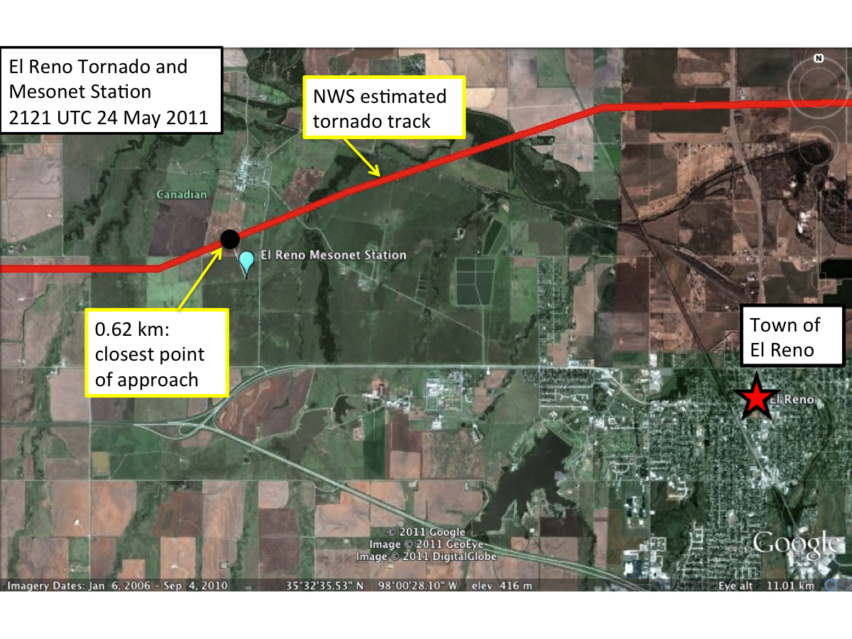
Attached is a
Google Earth map
of the El Reno, OK, tornado track as estimated by WFO OUN. Based on
the NWS-estimated tornado track path, the El Reno 1-min mesonet station
observations, and the latitude and longitude of the mesonet site, we estimated
that the closest approach of the tornado to the mesonet site was ~ 0.61 km at
~2121 UTC 24 May 2011.
El Reno, OK, mesonet site
information: http://www.mesonet.org/index.php/sites/site_description/elre
Even more
rotatingly yours.....and not too long
"winded" this time.....
Lance and Fred
From: Fred Carr
<fcarr@ou.edu>
Subject: Re:
Mesonet station hit by tornado - update
Date: 25 May,
2011 19:42:11 GMT
To: Kyle
Griffin <kgriffin@atmos.albany.edu>, <emanuel@mit.edu>
Cc: SUNYA <map@atmos.albany.edu>
Map -
Here is a "Mesonet Ticker" summary of the El Reno tornado hit (or
near-miss), complete with 1-min. data. A mesonet operator visited the
site this morning and reported that debris is wrapped around the tower, the surrounding fences are down, and its southeast
guywire is snapped. All nearby trees were stripped. The site was
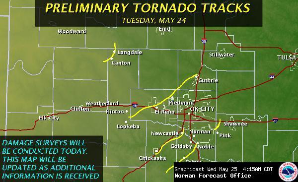
right on the southern edge of the tornado damage path. Info. about the tornado tracks, etc. is found at http://www.srh.weather.gov/oun/?n=events-20110524
So, what are the highest 10-m wind speed records (not counting MWN, DoW,
etc.)??
Fred
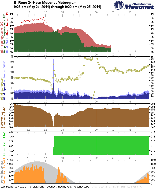
El Reno Mesonet measures 151 mph wind gust
The Oklahoma Mesonet site located
5 miles WNW of El Reno had a very close encounter with a tornado last night.
The twister in question was the long-track violent tornado that first touched
down north of Lookeba.
http://ticker.mesonet.org/archive/20110525/fxc_Storm_Summary.jpg
During that encounter, the
Mesonet site recorded a maximum wind gust of 151 mph, with a 1-minute average
wind speed of 115 mph. The 1-minute average wind speed amounts to 20 samples
averaged together. Definitely a bad hair day for the El Reno
Mesonet site.
The meteogram with that data
included is quite striking. The 150.8 mph wind gust stands out, obviously, as
as does the sudden drop in pressure as the tornado approached and either grazed
or passed over the Mesonet site.
http://ticker.mesonet.org/archive/20110525/ELRE.met.gif
If we drill down to the 1-minute
data, however, we get a more complete picture.
This view displays the 1-minute data from 4-5 p.m.
http://ticker.mesonet.org/archive/20110525/ElReno-1minuteMeteogram.png
At 4:21 p.m., the maximum wind
gust (WX1M - light blue) jumped to 150.8 mph and the average wind speed for
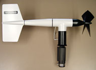
that minute (WS1M - dark blue) came in at 115.3 mph. The instrument that measured that wind speed
is an RM Young Wind Monitor:
http://ticker.mesonet.org/archive/20110525/data_pic_rmyoung.jpg
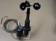
On the meteogram, our 2-meter
wind (W21M - red line) measurements had an average wind speed of 79.2 mph and a
maximum gust of 126 mph before obviously failing. That instrument is an RM
Young Wind Sentry cup anemometer:
http://ticker.mesonet.org/archive/20110525/data_pic_windsentry.jpg
It's unclear at this time whether
it failed due to the high winds or possibly wind-driven hail. A look at the
observations through time:
Time Max
Gust Avg
Speed Wind
Direction Pressure
(mph)
(mph)
(degrees)
(mb)
4:18
p.m. 61
47
207
947.0
4:19
p.m. 66
53
173
946.5
4:20 p.m.
131
81
159
936.6
4:21 p.m.
151
115
256
929.1
4:22
p.m. 91
77
294
940.5
4:23
p.m. 56
40
329
942.9
The 151 mph wind gust tops our
previous Mesonet record of 113 mph, recorded at the Lahoma site on August 17,
1994. That measurement was not associated with a tornado and the wind
instrument failed after being pelted with wind-driven large hail. Even the El
Reno AVERAGE wind speed of 115 mph tops that Lahoma gust, but we must remember
the Lahoma wind instrument failed.
The Mesonet's 100 mph gusts:
May 24, 2011:
151 mph at El Reno
May 24, 2011:
131 mph at El Reno
August 17, 1994:
113 mph at Lahoma
May 4, 2006:
106 mph at Idabel
November 9, 1998: 102 mph at Bowlegs
We will hopefully update this
Ticker with pictures from the site sometime later
today.
Gary McManus
Associate State Climatologist
Oklahoma Climatological Survey
(405) 325-2253
From: Howie
Bluestein <hblue@ou.edu>
Subject: update
Date: 25 May,
2011 15:38:03 GMT
To: Stephen
Moore <prothermographer@gmail.com>,
Ivan PopStefanija <popstefanija@prosensing.com>,
John Meier <pi@ou.edu>, "Dave B. Parsons" <dparsons@ou.edu>, Randy George <wgeorge@bcisse.com>, Chad
Baldi <baldi@prosensing.com>, <craig.wolter@windom.k12.mn.us>,
Louis Wicker <Louis.Wicker@noaa.gov>, Sam
Mortimore <sam.mortimore@pioneertv.com>,
"Dan Dawson" <Dan.Dawson@noaa.gov>,
"Jana B. Houser" <jana.b.lesak-1@ou.edu>,
"Frank Alessandro" <falessandro@bcisensors.com>, Robert Bluth <rtbluth@nps.edu>,
"Robin L. Tanamachi" <rtanamachi@ou.edu>,
"Michael M. French" <mfrench@ou.edu>, Fred
Carr <fcarr@ou.edu>, "Kathleen E. Welch" <kwelch@ou.edu>, Dave Emmitt <gde@swa.com>, Samantha Lambart
<samantha.lambart@pioneertv.com>,
Vivek Mahale <vmahale@ou.edu>, Tim Samaras <tsamaras@ecentral.com>, "Andrew L. Pazmany" <pazmany@prosensing.com>, "Donald Burgess" <Donald.Burgess@noaa.gov>, <jennifer_adams@sbcglobal.net>,
"Jeffrey C. Snyder" <wxguy1@ou.edu>,
Morris Weisman <weisman@ucar.edu>, Paul
Buczynski <PBuczynski@nps.edu>, Lance
Bosart <bosart@atmos.albany.edu>,
"Robert D. Palmer" <rpalmer@ou.edu>, Howie
Bluestein <hblue@ou.edu>, <michaelfish@blueyonder.co.uk>,
Timothy Maese <tmaese@bcisensors.com>, <becky@orangeonastring.com>, John Brown <john.m.brown@noaa.gov>
Cc: "Bradley
F. Smull" <bsmull@nsf.gov>,
"Stephan P. Nelson" <snelson@nsf.gov>
Hi all:
Status: RaXpol up; MWR up;
TWOLF down; status unknown; NOVA film crew leaving.
Yesterday: A chase for the
ages! Very brief summary: RaXpol collected data for about 50 min in
large, wedge, multi-vortex tornado that began to our southwest, from our
location WSW of El Reno, NE of Lookeba. When tornado was at its closest, just
to our S, we went for a period into tornado mode: 1 elev. angle (1 deg),
complete PPI every 2 sec. May have caught genesis to our SW in volume mode
(updates every ~ 20 s). Second deployment near Newcastle in ball of hook:
RaXpol collected data of Chickasha tornado; were surprised to find that
we were only 2 km from it. Also got Goldsby tornado, but at much longer range
(~ 25 km). Third deployment: near Tecumseh, but too far away to get tornado
that crossed I-40. All in all three tornadoes, two very close, and one huge. We
will check wind speeds in clear air today in tornado mode, just to be sure of
our wind estimates. Great polarimetric signatures.
More later. Lots of photos, videos, and NOVA film crew documented everything.
MWR-05XP had two deployments on the first, large tornado. One W of El Reno (9
min), the other just S of El Reno (29 min); second deployment, updates every 5
-9 s, up to 40 deg. elev. angle. MWR attempted to intercept Chickasha tornado
also, but were hampered by roads blocked with debris. We had the same problem, but
managed to get around, but were substantially slowed down. Outstanding
deployments. We lost cell phone contact between radars, were out of radio
range, and could not coordinate. May be serendipitous dual-Doppler rapid-scan
possibilities, but it will be a bit before we can assess. A great job by
everyone and kudos to the radar designers/software developers! Also, we may be
able to correlate El Reno mesonet ob with our data.
Today: damage surveys; both
RaXpol and MWR-05XP teams should use private cars to determine how far away
damage paths were from radars during deployments and take photos of damage.
Tmw: down
Friday: field operations
possible locally.
Beyondo: unclear; predictability low. May be chances on Sat. in KS. Overall long term pattern does not look favorable, but I trust
nothing.
Thanks to my team of
professionals!
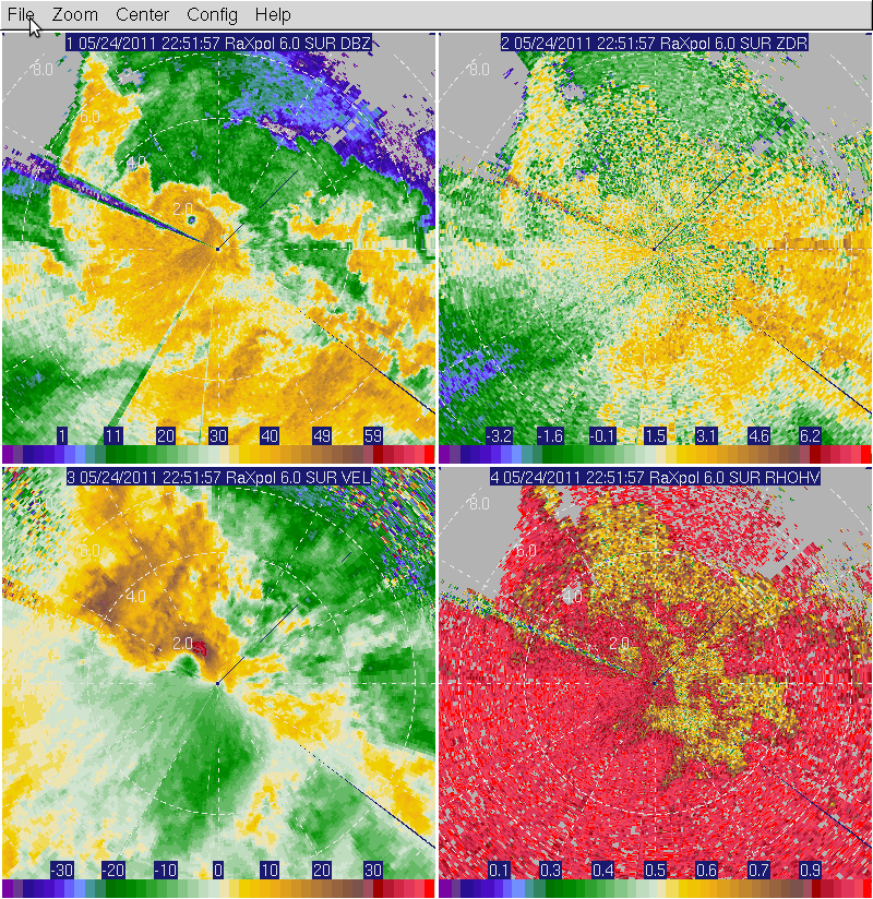
A few sample RaXpol images
courtesy of Jeff at end: Samples from all three tornadoes shown. Signs of
velocity I think are still reversed. First two images: tornado between El
Reno and Lookeba (image
1, image
2); third
image: Chickasha tornado. Fourth
image: Goldsby tornado. The quality of the latter is
degraded because of attenuation and we were in fast mode.
BTW, data from the day before
were outstanding also. Beautiful hail signatures I had forgotten to point out
in yesterday's msg. Have not had time to look at data
when funnel appeared.
Please do not pass these images
around or post them. They are raw, unedited, uncalibrated data.
My apologies to Tim Samaras, who
is on my list in my office, but I just discovered is not on my list here at
home. There may be others who are intermittently not being sent e-mails.
Howie Cb
Howard B. (Howie "Cb")
Bluestein
Professor and George Lynn Cross
Research Professor
School of Meteorology
University of Oklahoma
120 David L. Boren Blvd., Suite
5900
Norman, OK 73072-7307
405-325-6561
FAX 405-325-7689
Amateur Radio K1RHZ
From: Kyle
Griffin <kgriffin@atmos.albany.edu>
Subject: Re:
Mesonet station hit by tornado
Date: 25 May,
2011 00:10:16 GMT
To: <emanuel@mit.edu>
Cc: Fred Carr
<fcarr@ou.edu>, SUNYA <map@atmos.albany.edu>
Kerry (and all):
Surprisingly, it may not have
been quite a direct hit. Watching here from the HWT as well, the closest point
of approach was at the 21:18 UTC scan (4:18 local; see
attached KTLX reflectivity/base velocity image) and was about 0.5-0.75 miles
from the center of the velocity couplet. Depending on the size of the tornado -
the couplet was weakening at the time - it was likely in the near-periphery. It
will likely take plenty of additional data (Howie's data especially) to be sure
of this. We've also heard of 1-min data recorded by the station, and the folks
from OU say this could be made available soon. If the current data (at 5-min
resolution) can gust to 151mph, it should be quite interesting to see how high
the wind went and how low the pressure fell.
Kyle
-----------------------------------------------------
Kyle S. Griffin
Dept. of Atmospheric and
Environmental Sciences
University at Albany, SUNY
1400 Washington Ave, Albany, NY
12222
Office: ES-218
Email: kgriffin@atmos.albany.edu
http://www.atmos.albany.edu/student/kgriffin/
From: Fred Carr
<fcarr@ou.edu>
Subject: Mesonet
station hit by tornado
Date: 24 May,
2011 22:20:01 GMT
To: SUNYA <map@atmos.albany.edu>
Dear Map -
Lance and I are sitting in
the SPC/NSSL Hazardous Weather Testbed in Norman watching all the action on 67
computers and TV sets. At 4:25 CDT, one of the tornadoes "debris
ball" as seen
on the radar image went directly over the El Reno
Mesonet site - the meteogram
is attached. Remarkably, the
anemometer survived the 150 mph hit. We are not going storm chasing as there is a good chance the storms will come right
to us in an hour or so.
Rotatingly yours,
Fred and Lance