Map,
I thought I’d check out some synoptic-scale precursors to the
potentially widespread severe weather event over the Plains anticipated for
this Friday the 23rd (see SPC’s Day 3
outlook). The most obvious
precursor to the deep upper-level trough forecast to dig over the western U.S.
(see, e.g., the 1200 UTC 2/21 54-h GFS forecast
obtained from the University of Utah webpage)
is an impressive 19–21
February upstream ridge eruption over the central Pacific. The following images show the poleward
eruption of high potential-temperature air on the dynamic tropopause (DT)
between about 160°E
and 170°W
from a “northern polar” perspective (taken from the McTaggart-Cowan
GFS diagnostic animation builder):
This ridge eruption appears to have occurred in response to a
relatively intense cyclone associated with high values of layer-mean 850–925-hPa cyclonic relative vorticity
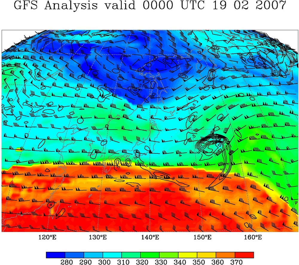
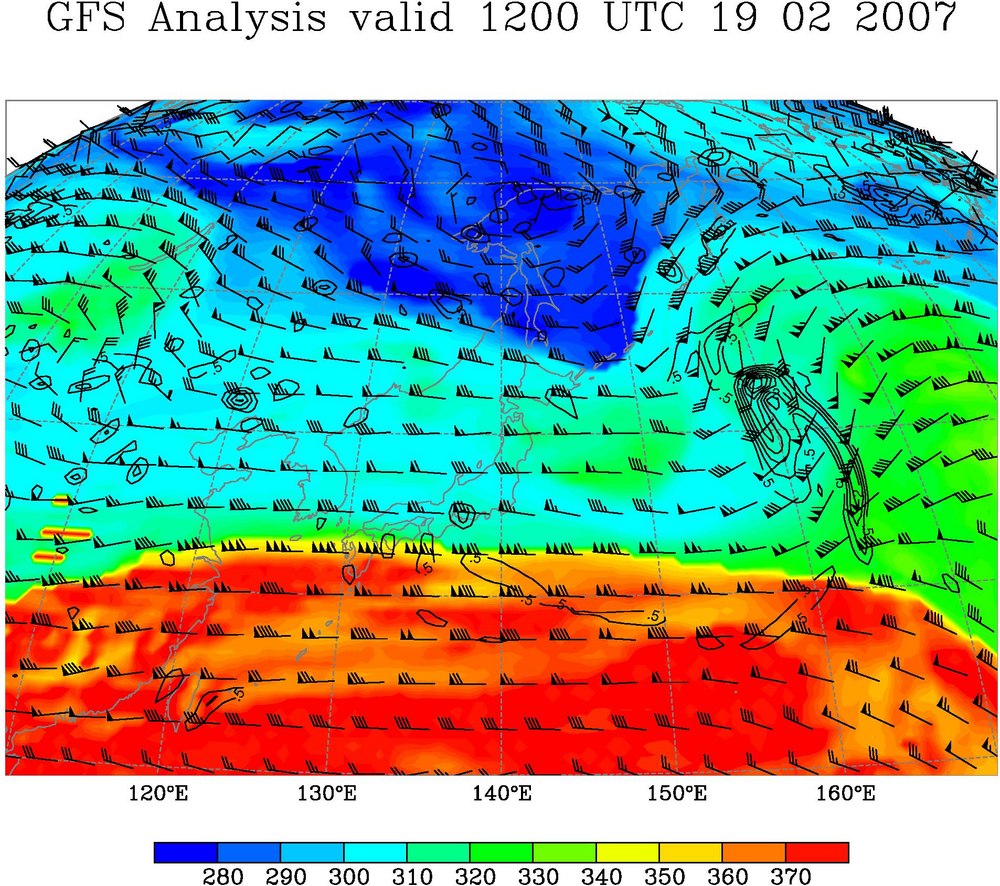
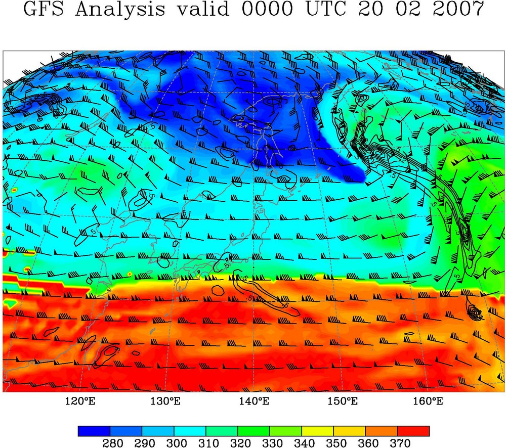
(black contours in the above figures) initially near 155°E on 0000 UTC 2/19.
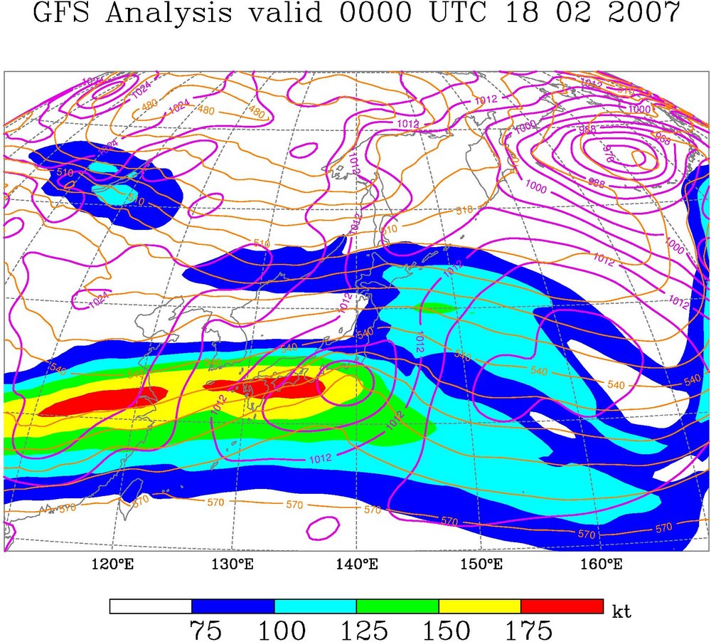
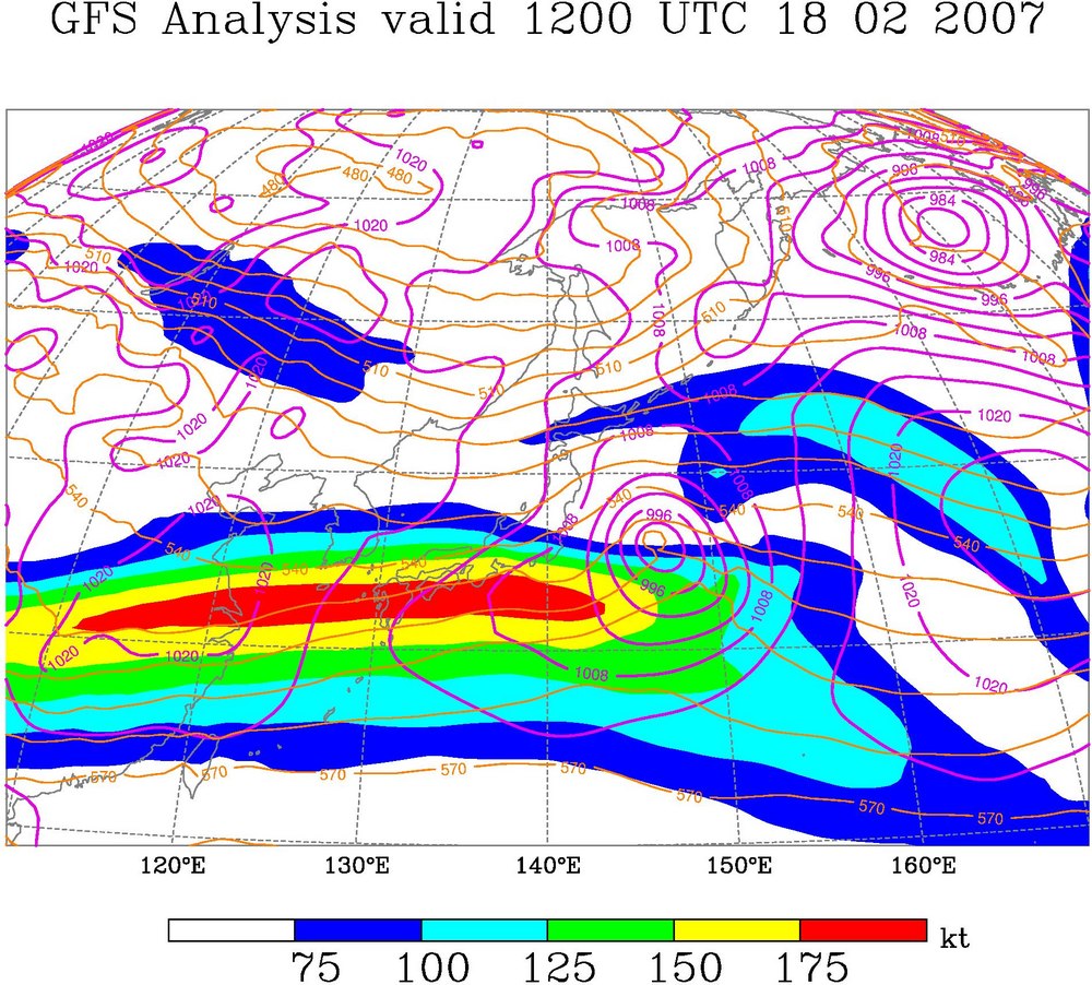
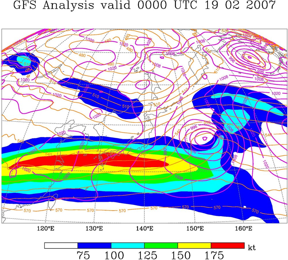
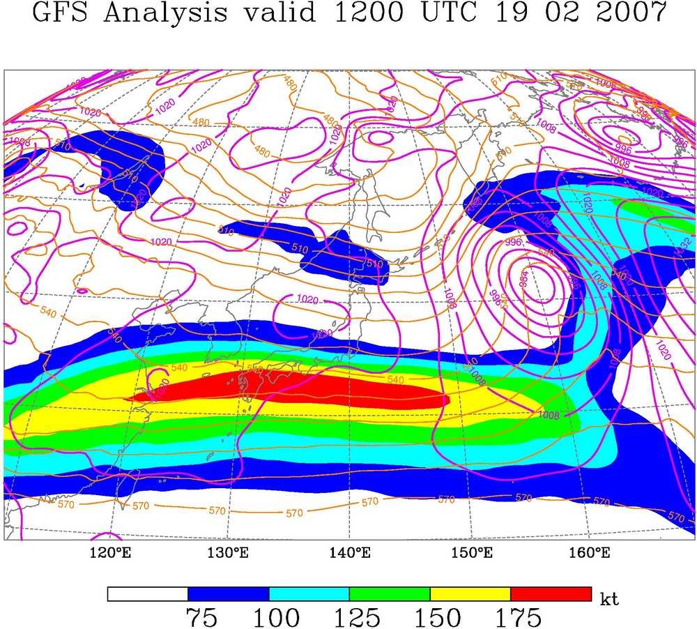
The following images show the evolution of this cyclone
between 0000 UTC 2/18 and 0000 UTC 2/20 (same maps as before, except from a
West Pacific/Asia perspective):
Of particular interest is that this cyclone appears to have
originated along the southern wave guide (indicated by the tight meridional
potential temperature gradient) located near 30°N before being “handed off” to the
northern wave guide located near 45°N by 0000 UTC 2/20.
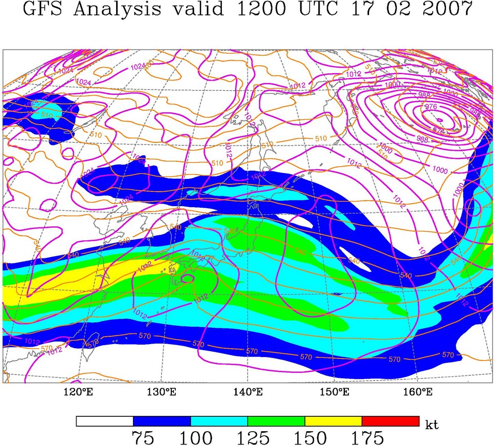
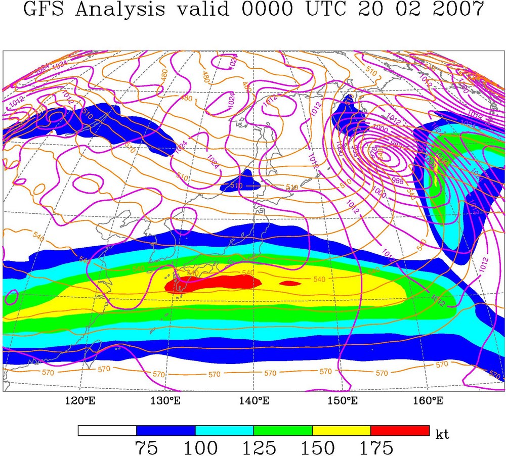
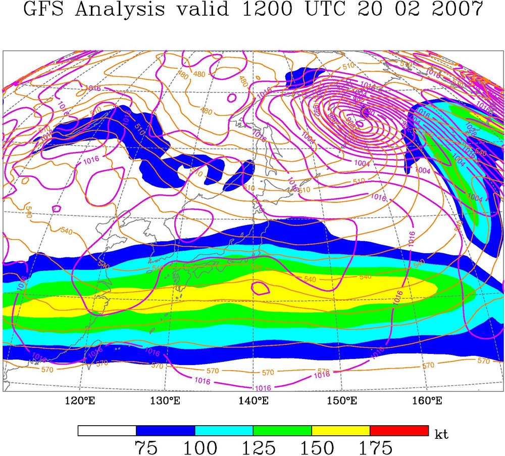
The last set of images (from the same source; 300-hPa wind,
1000–500-hPa
thickness, and SLP) shows
that the evolution of the jet associated with the cyclone:
At the start of the period (1200 UTC 2/17 and 0000 UTC 2/18),
the cyclone is tied to the exit region of an intensifying, zonally oriented
subtropical jet streak over eastern
Judging by the initial development of the cyclone in the exit
region of an intensifying subtropical jet streak over eastern China and the
West Pacific Ocean, it seems that the intensification of the subtropical
potential-temperature gradient on the DT associated with jet streak formation
over this region is an important precursor to the severe weather event over the
Plains expected for this Friday.
Now, some questions:
o
Is
the development of the subtropical jet streak linked to diabatic outflow from
tropical deep convection?
o
How
often do West Pacific cyclones originating in the subtropical jet reach high
latitudes (this cyclone originated near 32°N and reached approximately 60°N)?
o
Is
the genesis of these types of cyclones inherently less predictable than the
genesis of purely extratropical cyclones?
Comments/contributions welcome…
Heather
………………………..
Email responses
(updated 2/21):
o
1. From Lance to me (2/21):
…The STJ influence is clear. The arctic PV anomaly is coming
into
play only at the most recent time
available (00Z/21).
I would add one more question: Is the arctic PV anomaly the
extra ingredient needed to pull the
ridging even further poleward
into high latitudes so as to maximize the
possibility for downstream
development to occur and, if so, is this another
predictability issue?
………………………..
o
2. From me to Lance (2/21):
I do think the arctic PV anomaly is probably necessary for
ridging at the
higher latitudes, and thus, downstream
development. Without its
influence, I imagine that the cyclone would
have had a more zonal track and the
bent-back ridging into high latitudes would
not have occurred…If
we do get a great severe wx outbreak, it could be very interesting to look at
the event for a range of temporal and
spatial scales.
………………………..
o
3. From Ryan Maue to
me (2/21):
I spent a while compiling the ERA40 storm tracks and writing
fancy code to
whip up any sort of filter one can dream
up.
So, I would like to weigh in on your questions. Feel free to add whatever
to your discussion, or tell me I am
completely wrong…
Is the development of the subtropical jet streak linked to diabatic
outflow from tropical deep convection?
>> I could envision enhancements caused by Tropical
convection, however,
the mean large scale circulation during
Jan - Feb has the jet max
located off the tip of
genesis region in the Northern Hemisphere.
How often do West Pacific cyclones originating in the
subtropical jet
reach high latitudes (this cyclone
originated near 32°N and reached
approximately 60°N)?
>>
Since the vast majority of W Pac cyclones originate off this jet,
it is
interesting to see what is special about a
cyclone that makes it to
north of say 55N. Obviously, if it has the ability to travel
about 20
degrees of latitude, there is considerable
upper-level
steering/shear/baroclinicity for sustained and especially
explosive
growth, oftentimes.
So, in phishing through the ERA40
for Januarys and Februarys 1958-2002, I
filtered out cyclones that originated near the
STJ location (see figure)
and required the cyclone to travel north
of 55 degrees. I only consider
storms that last longer than 24 hours,
undergo at least 2 mb of
intensification in 24 hours, and achieve a minimum
central pressure of
lower than 1003 mb.
I got 175 such cyclones (~2 per year in each month) of which
102 are
"bombs" or undergo rapid
deepening of 1 bergeron (geostrophically
adjusted
to 45N) for a period of 24 hours. The average duration of these cyclones
is 6 days and on average have intense
warm core structure at the surface
according to Hart (2003) phase space
characteristics (-VTL = 129 mean
value for the 175 storms) --> Hence they are bona fide warm seclusions,
which are my dissertation topic (shameless
plug).
More trivia: These cyclones
on average reach their minimum SLP at 50N.
Is the genesis of these types of cyclones inherently less
predictable than
the genesis of purely extratropical
cyclones?
>> These are the archetype extratropical cyclones, I
see nothing impure about
them. No clue about forecasting.
I also attached some frequency/density cyclone phase plots
for the overall
tracks and genesis of these cyclones.
Captions:
(1) Cyclone phase
space density plot: -VTL vs B for all track points of
the 175 cyclones that originiate in the "genesis" box and exceed 55N
during Jan and February. Binsizes for the
density plot are 20 for -VTL
and 5 for B. Thus, the vast majority of the cyclones'
lifecycle occurs
in the lower-level warm core/symmetric
area of the cycphase.
(2) Same as (1) except -VTL vs
-VTU. Binsizes
are 20 by 20.
(3) Genesis density plot for the 175 cyclones. Thus, the -VTL and B for
the 175 cyclones -- showing strong
cold-core asymmetric structure at the
beginning of their lifecycle.
(4) Same as (3) but for -VTL and -VTU. Full tropospheric cold-core
structure.
(5) The lat/lon positions of the 175 cyclones are binned and counted.
Their density is plotted with the maximum location scaled to
25.
(6) Storm tracks.
Compare to (5).
………………………..
o
4. To Ryan from me (2/21):
Wow, really great stuff, Ryan…Hopefully I'll have some more
comments for you once I take the time to look at your figures more carefully...
A point of clarification:
in my last question ("Is the genesis of these types of cyclones
inherently less predictable than the genesis of purely extratropical
cyclones?") I meant the genesis of cyclones over the subtropics vs. over
higher latitudes - I didn't mean to imply that these are not extratropical
systems.
………………………..
o
5. To Ryan from me (2/21):
Hi Ryan,
To clarify, in regards to your comment about the cyclones
having surface warm core characteristics, I assume you are referring to
characteristics at the end of their life cycles (once they reach 55°N)?
Following up on your comment about the position of the
climatological jet max off the tip of
Perhaps surprisingly, this particular cyclogenesis event
appeared to be forced by dynamics associated with the exit region of a jet
streak over
Heather
o
6. From Ryan to me (2/21):
Heather,
These cyclones only have cold-core structure in the
lower-troposphere
during their most rapid development period,
whether they qualify as a
"bomb" or not. Thus, the
average bomb in the Pacific reaches its minimum
SLP (and max gale radius) in 60 hours, its maximum -VTL in 66
hours (6
hour lag from the MSLP), its maximum -VTU
in 74 hours, and lysis at 115
hours.
The long period between minimum SLP and lysis
is largely spindown
of the equivalent barotropic structure,
I would surmise. Hence, marine
"bombs" have a positive
VTL for ~60% of their lifecycle.
Calculation of
the VTU parameter between (600-300 hPa)
is contaminated by the low
tropopause and intrusion of stratospheric air
(hi PV), so it is not
necessarily as valuable for extratropical
systems.
I don't know of a quick way to test whether a given cyclone
is in the
entrance/exit region of a jet without manually
eyeballing them. Any ideas
on how to automate?
I removed the requirement that the cyclones must reach 55N
and gathered
new statistics.
This time: got 561
cyclones from the genesis box (~14 a year) and 255
bombs and a MSLP reached at 45N. Thus, there seems to be a significant
difference in terms of "explosive"
capability for storms that exceed 55N,
since the percentage of bombs is 60%
(exceed 55N) versus 45% (no latitude
restriction).
These cyclones that have a strong meridional component of
motion seem a
lot like extratropical transition (ET)
storms, where the configuration of
the jet (zonal index) determines a lot
about intensification (i.e. Klein
et al. 2001)
Cheers
RYAN
o
7. From Ryan (2/22; follow-up on post 3):
The maximum mean -VTL of 129 represents simply
the MAX -VTL for each of the 175
cyclones and is only one point out of an
average of 19 (avg. duration from genesis to
lysis). Thus,
on the density
plot, their "weight" or
frequency does not show up as a bullseye.