Map Disco: 2 November
2012
Sandy: A Recap
In House Analysis and Forecast Maps
DT-Theta,
Winds, 925-850 Layer Mean Cyclonic Relative Vorticity
(16 Oct - 03 Nov) - NCEP Operational Analysis
MSLP,
250 hPa Wind Magnitude, PV, Irrotational Winds, Precipitable
Water, 500 hPa Vertical Velocity, (16 Oct - 03 Nov) - NCEP Operational Analysis
500
hPa Geopotential Height, Cyclonic Vorticity, Vertical Velocity
(16 Oct - 03 Nov) - NCEP Operational Analysis
850
hPa Temperatures, Winds, Vertical Velocity, MSLP (16 Oct - 03 Nov) - NCEP Operational Analysis
Model Verification and Discussion
"Why
European forecasters saw Sandy's path first" Scott K. Johnson (Ars Technica)
-
Poor performance of high-resolution models (e-mail) Cliff Mass (University of Washington)
-
Image 1 (e-mail) Cliff Mass
(University of Washington)
-
Image 2 (e-mail) Cliff Mass
(University of Washington)
Hurricane
Forecast Model Output (Archive) University of Wisconsin - Milwaukee
PSU
WRF/EnKF Atlantic Hurricane Forecasts (Archive) Penn State University - Department of Meteorology
Hourly
ECWMF SLP Frames as Sandy Makes Landfall (12 UTC 29 Oct - 00 UTC 31 Oct) - Tim Hewson
(Maplist)
Model
Simulation Depicting Ertel-PV (FIM G8) (12 UTC 27 Oct - 00 UTC 01 Nov) - Rainer Bleck
(Maplist)
Synoptic
Map of Sandy Depicting Geopotential Height, 250 hPa Ageostrophic
Wind Vectors, Divergence, and Isotachs (00 UTC 28 Oct - 12 UTC 30 Oct) - Colorado State
GFS
Analysis E/W Cross Sections of Hurricane Sandy (15 deg E/W from
center) (00 UTC 23 Oct - 00
UTC 31 Oct) - Alicia Bentley
GFS
Analysis E/W Frontogenesis Cross Sections of Hurricane Sandy (15
deg E/W from center) (00 UTC
23 Oct - 00 UTC 31 Oct) - Alicia Bentley
ECMWF
Panel Map of Solutions for 00 UTC 30 Oct (Every 12 hours starting 10 days before landfall)
- Tim Hewson (Maplist)
GFS
Panel Map of Solutions for 00 UTC 30 Oct (Every 12 hours starting 10 days before landfall)
- Cliff Mass (Maplist)
Comparison
of 2010 Record SLP for Midwest with 1978 Cleveland Superbomb
(00 - 12 UTC 26 Oct 2010 compared to 00 - 12
UTC 26 Jan 1978)
Impact: Images and Articles
Hurricane Sandy
Response Imagery Viewer National
Geodetic Survey - NOAA
Photos
of Surge / Beach Erosion Damage in New Jersey Flickr
Arial
Photos of Surge Damage in New Jersey St. Petersburg Coastal and Marine Science Center
- USGS
Arial
Photos of Surge Damage in New York St. Petersburg Coastal and Marine Science Center
- USGS
Interactive
Map of Oblique Photo Before and After Photos St. Petersburg Coastal and Marine Science Center
- USGS
Coastal
Change Forecasts via NHC Advisories St. Petersburg Coastal and Marine Science Center
- USGS
Images
of Star Jet roller coaster at the Casino Pier in Seaside
Heights, NJ
East
Coast Rainfall Totals (contoured w/ black background) (24-31 Oct) - David Roth (HPC)
East
Coast Rainfall Totals (filled w/ black background) (24-31 Oct) - David Roth (HPC)
East
Coast Rainfall Totals (filled w/ white background) (24-31 Oct) - David Roth (HPC)
Mid-Atlantic
Rainfall Totals (contoured w/ black background) (24-31 Oct) - David Roth (HPC)
Mid-Atlantic
Rainfall Totals (filled w/ black background) (24-31 Oct) - David Roth (HPC)
Mid-Atlantic
Rainfall Totals (filled w/ white background) (24-31 Oct) - David Roth (HPC)
Snowfall
Totals (contoured w/ black background) (28-31
Oct) - David Roth (HPC)
Snowfall
Totals (filled w/ black background) (28-31
Oct) - David Roth (HPC)
Snowfall
Totals (filled w/ white background) (28-31
Oct) - David Roth (HPC)
Science,
Satellites, and Superstorms: Preparing for the next big one
- Tricia Escobedo (CNN)
Observations: Satellite, Radar, Aircraft,
Surface
CIMMS
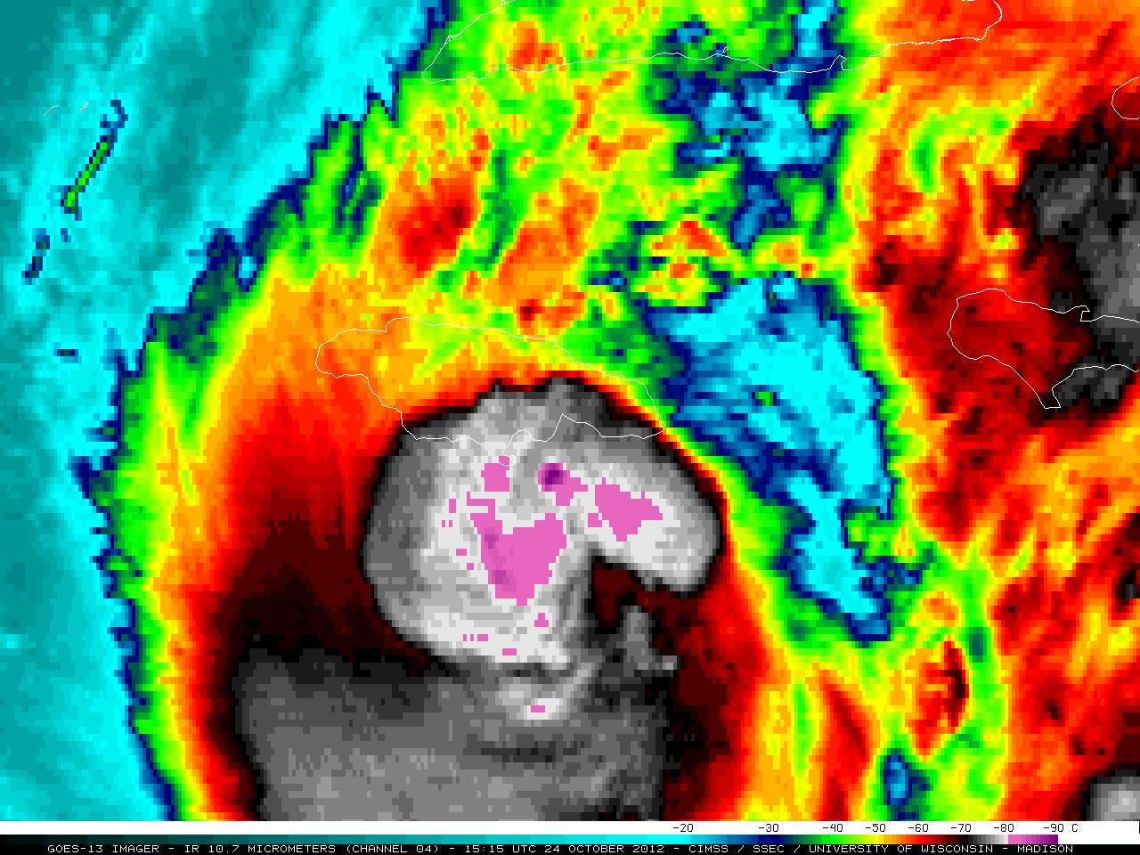
Satellite Blog on Hurricane Sandy (24 October 2012) University of Wisconsin - Madison
CIMMS
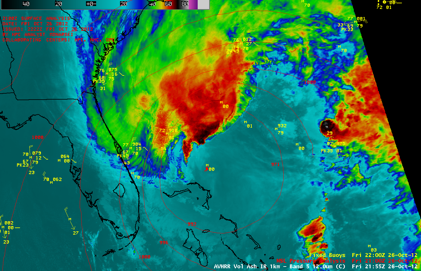
Satellite Blog on Hurricane Sandy (27 October 2012) University of Wisconsin - Madison
CIMMS
Satellite Blog on Hurricane Sandy (30 October 2012) University of Wisconsin - Madison
CIMMS
Satellite Blog on Hurricane Sandy (2 November 2012) University of Wisconsin - Madison
Satellite
Image of Sandy: Large View (1445
UTC 26 Oct) - GOES 13 - NOAA Environmental Visualization
Laboratory
Satellite
Data Tropical Cyclone Page The
Fleet Numerical Meteorology and Oceanography Center - NCP
IR
with superimposed Surface Obs as Sandy makes landfall
(2332 UTC 29 Oct) Greg Carbin (Maplist)
1 km Visible
Satellite Loop from GOES-14 in Super Rapid Scan Operations
(28 October) - SSEC - University of Wisconsin
- Madison
Brian
McNoldy's Radar Loops of Landfalling Tropical Cyclones
University of Miami
Track
Map of TC Sandy ACTF -
Created By Brian Tang
Satellite
Derived Sea Surface Temperatures over Western Atlantic Basin
NOAA/NESDIS
US
Radiosonde Archive for Sandy (21
Oct - 30 Oct) - Storm Prediction Center
US Radiosonde
Archive (Past Seven Days) (25
Oct - 02 Nov) - Storm Prediction Center
Analysis
Imagery from NOAA P-3 Flights into Sandy AOML - NOAA
NOAA-P3 Dropsonde
Observations (25 Oct - 28
Oct) - Atlantic Oceanographic & Meteorological Laboratory
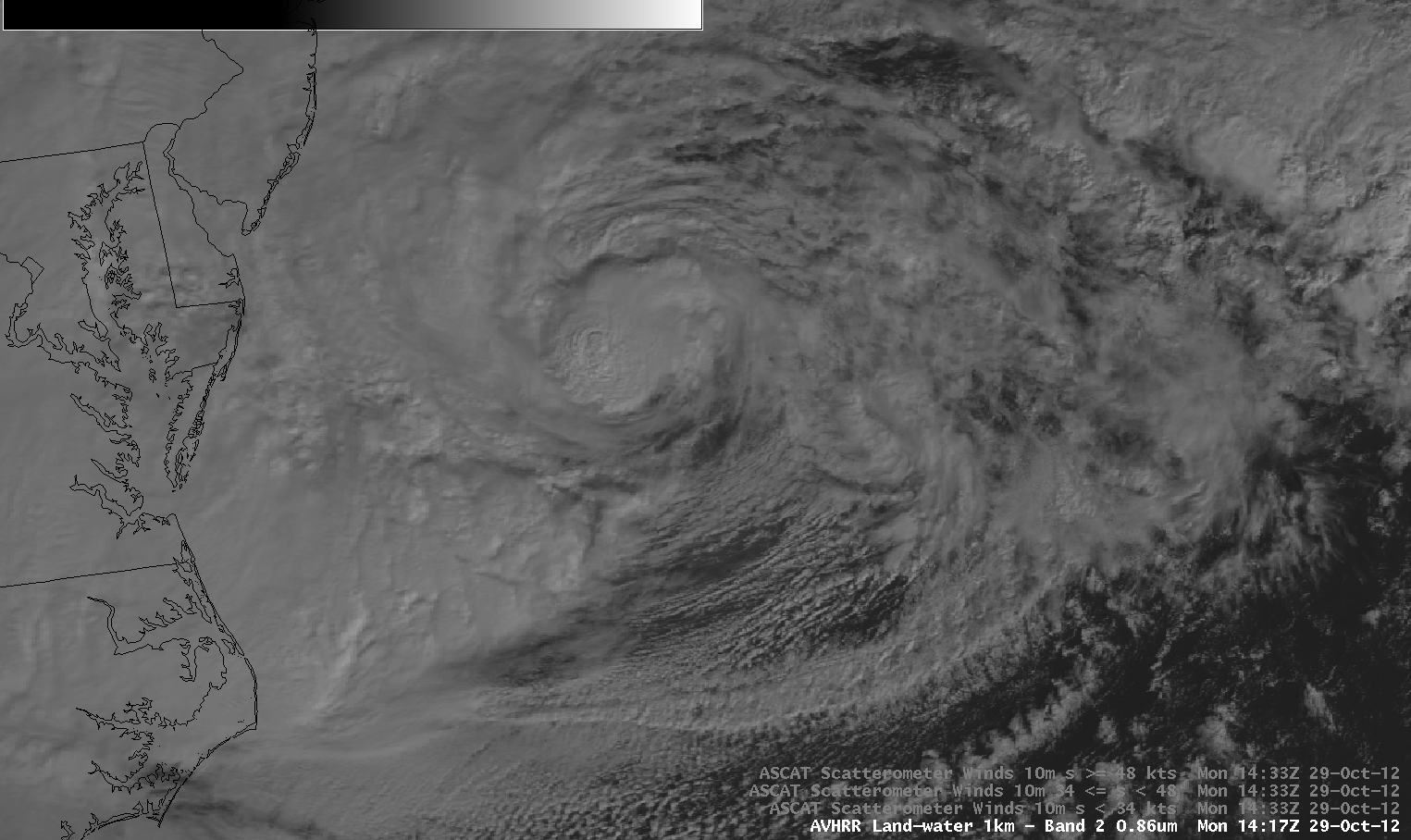
ASCAT
Pass Over Sandy (1419 UTC 29
Oct) - Joseph Slenklewicz (Maplist)
METER
Surface Plot Animation (00
UTC 29 Oct - 12 UTC 30 Oct) - RAP Real Time Weather Data - NCAR
Highest
Surface Wind Observation Graphic (29-30 Oct)
Northeast
Plot Showing METAR winds above 50 and 65 knots (29-30 Oct) - Florida State University - Bob Hart
Level
II Radar Estimation from Hurricane Sandy (25 Oct - 01 Nov) - National Mosaic and
Multisensor QPE - NSSL
Interactive
Snow Information (Archive and Current) NOHRSC - NOAA
Snow-depth
animation over the Appalachian Mountains (00 UTC 29 Oct - 12 UTC 01 Nov)
High On
LeConte - LeConte Lodge Blog Observations
and Imagery
Other Miscellaneous Products
Questions
about Sandy (e-mail) Jack
Beven (National Hurricane Center)
Multiple
Extratropical Transitions (e-mail) Kerry Emanuel (MIT)
Poor
Storm Surge Forecasting (e-mail) - Bryan Norcross (The Weather Channel)
Powerpoint
Presentation Comparison Between Irene and Sandy Louis Uccellini - Director of NCEP (.png
loop)
Rainfall
Forecast and Verification with Sandy (12 UTC 24 Oct - 12 UTC 01 Nov) -
Hydrometeorological Prediction Center
Ensemble/Deterministic
Model Forecast Plots NOAA
ESRL - Experimental
Tropical
Cyclone Guidance Project RAL
- NCAR
WunderMap
Weather Underground - Useful for Real Time
ECMWF Data
Cold-Season
Analog Guidance Cooperative
Institute for Precipitation Systems - Saint Louis University
Cyclone Phase
Evolution - Analyses and Forecast Robert Hart - Florida State University
Allan's
Model and Weather Data Page Allan
Huffman
GFS
Ensemble Sensitivity Analysis SUNY
Stony Brook & National Weather Service
GFS
N/S Cross Section at 71W (PV and Zonal Wind Speed) (12z 30 Oct) - Ryan Maue
GFS
Model Sensitivity to Cumulus Parameterization Nick Bassill - University of Wisconsin - Madison
Animation
depicting cold core transition of TC Sandy E-Wall - Penn State University
Real-Time Analysis and Other Products
Kyle
Griffin's Maps: Main Page
Ron-Mctaggart
Cowan's DT Maps and Coupling Index
Heather
Archambault's 2012 GFS Analyses
Tom
Galarneau's Real Time Diagnostics
RAP-UCAR
Real-Time Weather Data
Digital
Typhoon - Typhoon Images and Information
PSD
Maproom - ESRL
NeXt
Generation Weather Lab - College of DuPage