Rich, Lynne, and others,
As I just briefly logged on, for another reason, and spied your
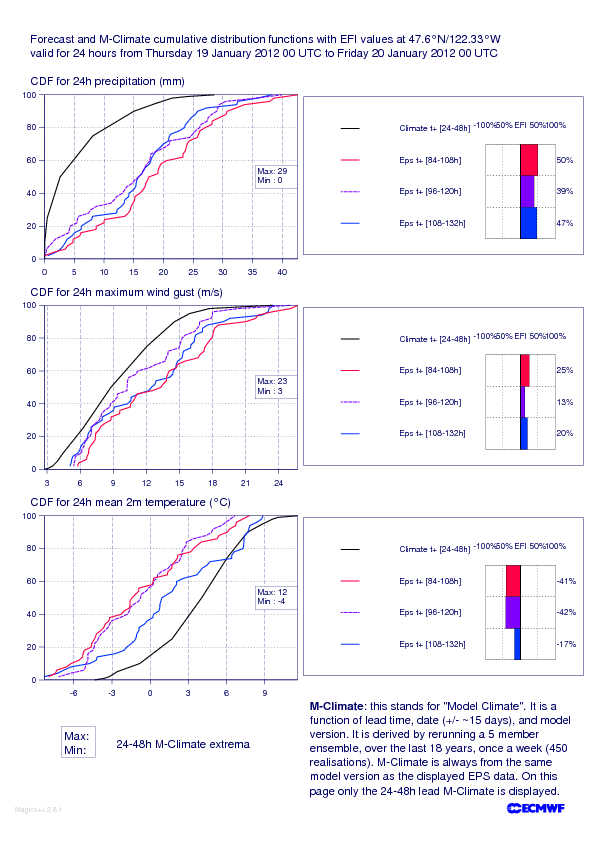
question, here is an EFI CDF plot for Seattle. From which you may conclude:
Wet or very wet or dry or snowy or very snowy or slushy. And maybe windy
and maybe not. And I am sure there is scope for plenty of local detail
to be added to this! :)
For reference EPS is ~60km resolution at this range, so the mountains
will not be very well handled.
Similar plots for places further S (not attached) denote higher
confidence of very wet, as, synoptically, one would expect.
Tim
Richard Grumm wrote:
The pattern is ideal for the NCEP models as the GEFS is showing a huge
closed 100 mm with some smaller 125 and 150 mm contours in the
west for total QPF.
High plume of moisture, westerly winds, big mountains and models know big QPF.
Should be iteresting.
Anyone have access to the EFI. This must be a top 80 or 90
percentile rainfall event in the model atmosphere. We need to know.
Rich
On Sat, Jan 14, 2012 at 7:55 PM, Sheldon Kusselson <sheldon.kusselson@noaa.gov <mailto:sheldon.kusselson@noaa.gov>> wrote:
Fred and others:
To add to the discussion....attached a powerpoint slide I made
showing the NOAA/NESDIS Blended TPW data and Percent of Normal
products for 23 UTC January 14 showing the moisture players that are
certainly getting organized this evening across the Pacific Ocean.
Interesting moisture plume/atmospheric river extending from the
Philippines to front just wast of the dateline and extending to near
high moisture north of Hawaii. If this works out, it will be more
than a pineapple connection...it could be the Southeast
Asia/Philippines mango-pineapple connection.
Sheldon Kusselson
NOAA/NESDIS
On 1/14/2012 23:41, Fred Carr wrote:
Or one could look at Squaw Valley web cams to get a closer look:
http://www.squaw.com/high-__camp-cam
<http://www.squaw.com/high-camp-cam>. Pretty sad sight for skiers!
Fred
On Jan 13, 2012, at 6:07 PM, Alexander Tardy wrote:
The incoming jet may be a little surprised to see the Sierra
Nevada (snow covered mountains) looking different.
-- Alex Tardy
Warning Coordination Meteorologist
National Weather Service, San Diego
<nsm_depth_2012011305
<tel:2012011305>_Western_Coastal.__jpg><MODISjan13.JPG>
--
*/Life is a journey not a destination./*
------------------------------------------------------------------------
--
==============================================================
Tim Hewson TEL: (+44 118) 9499046
ECMWF, Operations Section FAX: (+44 118) 9869450
Shinfield Park
Reading. RG2 9AX. email: tim.hewson@ecmwf.int
Berkshire. UK. www.ecmwf.int
==============================================================
 | | Seattle-EFI.gif
43K |
|
|
|