Begin forwarded message:
Resent-From: <lbosart@ALBANY.EDU>
From: Clark Evans <a.clark.evans@gmail.com>
Subject: El Reno tornado phased
array radar loop
Date: 4 June, 2013 04:40:20
GMT+00:00
To: <MAP@listserv.albany.edu>
Reply-To: Clark Evans <a.clark.evans@gmail.com>
Hi all,
To add to the discussion of the
chaser activity surrounding the El Reno tornado, I'd like to pass along this radar
loop of the storm that was put together by the WDSS-II team. The radar data
comes from the National Weather Radar Testbed phased array radar at the Norman,
OK airport.
Note how the high spatiotemporal
resolution of the radar product shows the southward development of the supercell's
hook to the south-southwest of El Reno, followed by the mesocyclone
subsequently being "swallowed" back northward into the supercell's
"belly" as the storm moved east of El Reno. Other aspects of the
storm's evolution are also noteworthy, of course.
-Clark
---
Clark Evans
Assistant Professor, Atmospheric
Science Group
Department of Mathematical
Sciences
University of Wisconsin-Milwaukee
E-mail: a.clark.evans@gmail.com
Phone: 414.229.5116
Web: http://derecho.math.uwm.edu/
Begin forwarded message:
Resent-From: <lbosart@ALBANY.EDU>
From: Howie Bluestein <hblue@OU.EDU>
Subject: Fwd: El Reno tornadoes
Date: 3 June, 2013 01:25:47 GMT+00:00
To: <MAP@listserv.albany.edu>
Reply-To: Howie Bluestein <hblue@OU.EDU>
From: Howie Bluestein <hblue@ou.edu>
Date: June 2, 2013 7:49:22 PM CDT
To: <map@atmos.albany.edu>
Cc: Howie Bluestein <hblue@ou.edu>
Subject: El Reno tornadoes
Hi all:
In response to many requests for comments, I'm sending you copies of
my status update messages from yesterday and today. I'd be happy to comment
specifically on the dangers of chasing tornadoes from my perspective, but not
now because I haven't the time, and not now because I'd rather not participate
in a discussions while emotions are running so high.
Howie Cb
Howie Bluestein
Howard B. (Howie "Cb") Bluestein
Professor and George Lynn Cross Research Professor
School of Meteorology
University of Oklahoma
120 David L. Boren Blvd., Suite 5900
Norman, OK 73072-7307
405-325-6561
FAX 405-325-7689
Amateur Radio K1RHZ
Begin forwarded message:
From: "Bluestein, Howard B." <hblue@ou.edu>
Date: June 1, 2013 11:33:59 AM CDT
To: "Snyder, Jeffrey C." <jsnyder@ou.edu>, "Houser, Jana
B." <jana.b.lesak-1@ou.edu>,
"Mahale, Vivek" <vmahale@ou.edu>, "Palmer, Robert
D." <rpalmer@ou.edu>,
"Meier, John B." <pi@ou.edu>, "Bodine, David J."
<bodine@ou.edu>,
"Zhang, Guifu" <guzhang1@ou.edu>, Robert Bluth <rtbluth@nps.edu>,
Paul Buczynski <PBuczynski@nps.edu>,
David Lary <djl101000@utdallas.edu>,
"Andrew L. Pazmany" <pazmany@prosensing.com>, "Tanamachi,
Robin L." <rtanamachi@ou.edu>,
Dan Dawson <Dan.Dawson@noaa.gov>,
"Carr, Frederick H." <fcarr@ou.edu>, Morris Weisman <weisman@ucar.edu>,
"Welch, Kathleen E." <kwelch@ou.edu>, "Cavallo, Steven"
<cavallo@ou.edu>,
John Brown <john.m.brown@noaa.gov>,
"Parsons, Dave B." <dparsons@ou.edu>, Lance Bosart <bosart@atmos.albany.edu>,
William Harrison <wah091020@utdallas.edu>, "Kurdzo,
James" <kurdzo@ou.edu>,
Stephen Moore <prothermographer@gmail.com>, Roger Wakimoto
<wakimotoroger@gmail.com>,
Zachary Wienhoff <wienhof1@illinois.edu>, "Reif,
Dylan" <dylanreif@ou.edu>,
"Thiem, Kyle J." <Kyle.J.Thiem-1@ou.edu>, Chris Weiss <chris.weiss@ttu.edu>,
"Biggerstaff, Michael I." <drdoppler@ou.edu>, Davina Bristow <davina.bristow@bbc.co.uk>,
"Burgess, Donald W." <Donald.Burgess@noaa.gov>
Cc: "Bluestein, Howard B." <hblue@ou.edu>, "Wicker, Louis J."
<louis.wicker@noaa.gov>,
Michael French <mmfrench1981@gmail.com>
Subject: status update
Hi all:
Yesterday: Collected data using RaXPol in
a number of tornadoes near El Reno and points east and southeast (see
sample data below courtesy of Jeff). 1st deployment just N of El Reno, up
to 40 deg elev angle, documenting first storms and collision of S storm into
storms to N; 2nd deployment, S or SW or SE of El Reno, documenting entire
genesis to maturity of large tornado, satellite tornadoes, and an anticyclonic
tornado. Great photos of storm structure and broad tornado. Tornadoes formed to
our W and moved ESE'wd to our SSW; had to leave to escape large hail and gust
front. It seems we get into position too often N or NE of the hook. Early scans
were deep volumes; when tornado was close and mature, we scanned 0 - 5 deg in
one deg increments. More deployments, some stationary, some while moving.
Tornado dissipated and a new one formed just W of us at the tip of an RFD surge
while we were on I-40. Managed to stay E of tornado on I-40 (see WSR-88D images
at end). Some small pieces of debris were falling onto I-40 just ahead of the
radar truck as we strategically retreated to the E. Last deployment was E of
OKC on I-240 S of Tinker Air Field. Major interstates were parking lots. Very
dangerous situation, since tornado or potentially new tornado could have hit
where traffic was at a standstill: Lesson...don't get on an interstate to
try to outrun a tornado. An emergency manager escorted us with sirens and
flashing lights off an exit, bypassing all the traffic. Went home via Choctaw
Rd. and around Lake Thunderbird onto Stella Rd. ("Stella!! Stella!!
apologies to Tennessee Williams and Marlon Brando and Jerry Seinfeld) to Rt 9.
Power flashes at intersection of Stella and 9, but wind not strong there. Back
to W through tip of hook and safely home about 9:15 PM. No power last night and
still no power at our house. Special thanks to Jeff who worked hard to collect
data and navigate and to Jana, who drove safely and expertly. Much more
detailed and more accurate documentation to come later. Hope other radars were
out and there can be some intercomparisons or even dual-Doppler.
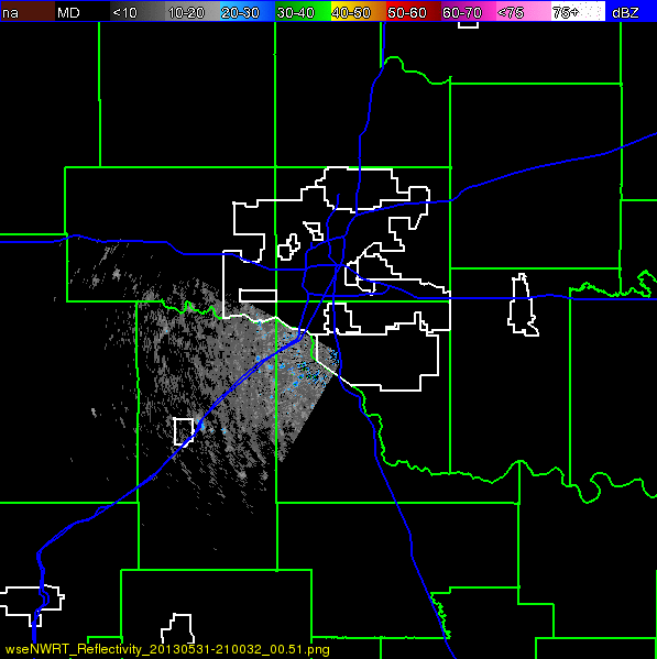
P. S. - Does Jeff ever sleep? Just got e-mail
showing some scans from Banner Rd. near I-40 with wind speeds as high as 118
m/s inbound at 4.75 km range at 1 deg elev. angle and 95 m/s outbound at 4 km
and 1 deg elev angle. Jeff reports many of the maxima were with subvortices
rotating around the main axis of the tornado.
Today and tomorrow: Down, thank goodness.
Next week: Possible field ops as moisture
backs up onto High Plains underneath weak to moderate NW/W flow. Will re-assess
later. May be field ops SW KS, OK Panhandle, N TX Panhandle. Crew:
Jeff, Vivek (?), and I. Am not leaving for Boulder quite yet. What an amazing
season!
Howie Cb
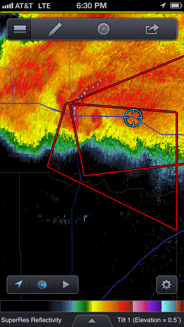
Note two eyes and vortex signatures; spiral
bands of debris seen in rhohv.
Frame grabs below from my iPhone of WSR-88D Doppler
velocity and radar reflectivity
factor from KTLX as we were being chased by a tornado down I-40. Our GPS
location is indicated by the blue circle. I-40 is the purple line.
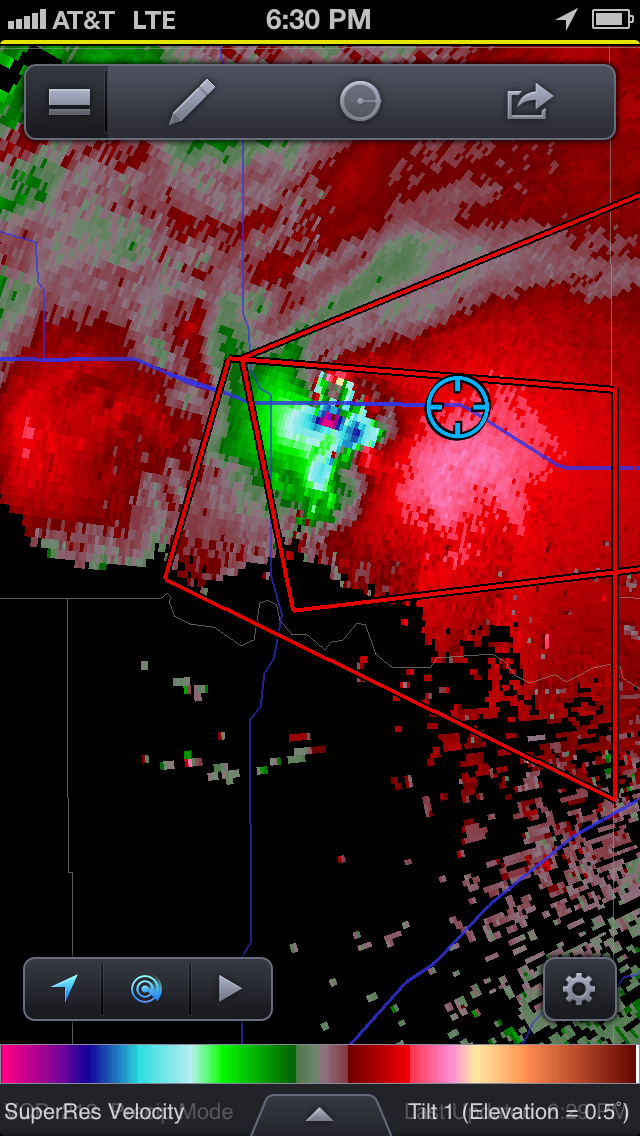
Hi all:
I am sad and shocked to tell those of you who have not already heard
that Tim Samaras, his son Paul, and Carl Young died while chasing the El Reno
tornado on Friday. While I have been receiving unconfirmed reports of this
since early this morning, the most recent, from Channel 7 in Denver (via Lou
Wicker), seems to confirm this tragic news. I have known Tim for many years as
someone who shared our enthusiasm for severe weather. He designed some of the
early miniature instruments deployed in the paths of tornadoes, particularly
those with video cameras and temperature and pressure sensors. His work has
been showcased and supported in part by the National Geographic Society, and
displayed at the Denver Science Museum. More recently he has been working with
high-speed lightning cameras. We have in the past, for a number of years,
shared our groups' status-update messages. He and Roger Hill ran the very
successful National Tornado Chasers' Convention in Denver each February. He was
always a gentleman and shared his enthusiasm with the community. While not an
academic or a member of a meteorological research laboratory, he has had a
profound influence on all of us, and in particular through publications of the
analyses of his data from TWISTEX.
On a related note, Jeff and Jana have found unofficial evidence of
wind speeds as high as 130 m/s in one of the satellite vortices we probed with
RaXPol on Friday. I prefer this estimate to remain unofficial (it may be
propagated, but only as UNOFFICIAL) until we have all had time to inspect the
data in detail. I do not want to rush to get this out just for its sensational
effect, but would prefer to be certain. Tim Marshall, Don Burgess, and Gabe
Garfield conducted a damage survey of the tornado yesterday. Roger and Jeff,
independently, conducted partial surveys. Much of the most intense portion of
the tornado's life was fortunately over open country where the potential for
loss of human life was minimized. In addition, markers are few and there will
likely be a controversy of what the rating of this tornado should be. We will
come up with an official radar estimate of max winds and someday publish it. If
the NWS rating is much less than EF-5 based on markers, then so be it.
Recently, radars have frequently been used to upgrade damage estimates, thus
corrupting the long-term record. Someone will undoubtedly use recent increased
numbers of strong tornadoes to infer that tornado intensity has been
increasing.
Data were collected also by AIR from a longer range, to our south,
and by a SMART-R. It may be, after the dust has settled, that dual-Doppler
analyses may be possible, especially because our locations seemed to have been
to the north of most ot the other radars. NOXP at North Base might be usable
later on when we reached OKC and E. I have heard reports that the Rapid DOW was
out, but I have no information on their deployment locations and times. We
should discuss all this next fall when I return to Norman. I hope to leave for
Boulder after the next possible field ops in the High Plains.
Today: down; enjoy the cool and dry weather.
Tmw.: Moisture progged to return tmw afternoon and high-based storms
psbl on the High Plains, particularly over SW KS and possibly the TX Panhandle,
where under moderate westerlies or NW flow supercell shear is possible. Standby
for possible relatively early departure. Cap will be substantial, but storms
that do form should have high temp - dew point spreads. Not sure if travelling
such a long distance will be warranted. Stay tuned. Early June can be a good
time for photogenic storms and good data collection opportunities.
Tues.: Sfc cyclone progged to be near Childress; adequate
moisture and shear for supercells expected in OK, but could be capped. Most
likely CI NE of cyclone along the front in OK. Field ops likely.
Weds.: A possible convective mess, as activity could occur all
day as Gulf air rides up over a front near the Red River. Tropical cyclone
forming in the E Gulf of Mexico?
Byeondo: Weak NW flow. Predictability low, but system should pass
on Sat. with CI. Details unclear.
Howie Cb
Howard (Howie "Cb") Bluestein
Professor of Meteorology and George Lynn
Cross Research Professor
School of Meteorology
University of Oklahoma
120 David L. Boren Blvd., Suite 5900
Norman, OK 73072
Main office 405-325-6561
FAX 405-325-7689
Office direct (upon request)
Cell (upon request)
Begin forwarded message:
Resent-From: <lbosart@albany.edu>
From: Clark Evans
<a.clark.evans@gmail.com>
Subject: OU RaXPol
image of the El Reno tornado
Date: 4 June, 2013
19:07:17 GMT+00:00
To: "Bosart,
Lance F" <lbosart@albany.edu>,
"Guastini, Corey T" <cguastini@albany.edu>, Morris Weisman <weisman@ucar.edu>
Probably not best for widespread
map-list distribution until/unless Howie has the chance to clarify, given that
I am not certain of how it came to be on social media. (RaXPol images are posted
here)
Also of note: a PowerPoint
slide put together by the Norman WFO describing, in a bit more detail, how
the radar data were used to estimate the tornado's maximum intensity.
-Clark
--
Clark Evans
Assistant Professor, Atmospheric
Science Group
Department of Mathematical
Sciences
University of Wisconsin-Milwaukee
E-mail: a.clark.evans@gmail.com
Phone: 414.229.5116
Web: http://derecho.math.uwm.edu/
Begin forwarded message:
Resent-From: <lbosart@albany.edu>
From: "Steven J. Weiss - NOAA Federal" <steven.j.weiss@noaa.gov>
Subject: Fwd: Significant Event Report -- Severe Weather from Texas
to the Great lakes, also Flooding Potential for the Missouri and Mississippi
River Basins
Date: 31 May, 2013 19:05:38 GMT+00:00
To: "Bosart, Lance F" <lbosart@albany.edu>
Lance,
Assuming you may be at MPEX now. The last day or two is
another example of combined severe storms/heavy rain/flooding that causes
considerable challenges in forecasting and communication of threats.
Enjoy Boulder.
Steve W
---------- Forwarded message ----------
From: National Weather Service Operations Center

Severe
Weather from Texas to the Great lakes,
also
Flooding Potential for the Missouri and Mississippi River Basins
Key
Points
•
Conditions
remain favorable for severe weather from Texas to the Great Lakes today.
•
Severe potential
moves slowly eastward over the weekend.
•
NWS Storm
Prediction Center (SPC) is again forecasting a Moderate Risk of
severe weather today for eastern Oklahoma, including the Oklahoma City
Metro and the Moore recovery area, as well as extreme southeast Kansas and
southwest Missouri.
•
In addition,
continuing heavy rainfall is likely into Saturday for the Missouri and
Mississippi River Basins.
◦
Flash flooding
and river flooding could be significant in parts of Iowa, Missouri and
Illinois into next week.
Reported
Impacts from Thursday and This Morning
◦
•
Several reports
of severe weather on Thursday:
◦
Broken Arrow,
Oklahoma: Damage to homes/businesses.
◦
Emergency
Management reporting one fatality in Tull, Arkansas from to a tree falling on a
vehicle.
◦
Softball-size
hail was reported in Bray, Oklahoma.
◦
Reports of
strong thunderstorm winds over 60 mph were reported from the central Plains to
the Great Lakes, with 80+ mph gusts in Des Moines, Iowa.
•
Heavy
rainfall continued over Iowa, Kansas, Oklahoma and Arkansas on
Thursday, resulting in significant river rises.
•
The Scott
County, Arkansas Sheriff's body was found after going missing in a
flash flood.
•
There is a
dam over-topping in Boonville, Missouri. Flash Flood warning issued
by WFO Pleasant Hill, Missouri for locations downstream.
Expected
Impacts
•
Severe
Thunderstorms:
◦
Today:
▪
A Moderate
Risk for severe weather exists again today over eastern Oklahoma,
which includes tornado recovery areas, as well as southeast Kansas and
southwest Missouri.
▪
A regional
severe weather outbreak is possible in the Moderate Risk area.
▪
Portions
of central/eastern Oklahoma will be considered for an upgrade to a High Risk at
4:00pm EDT dependent on conditions at that time.
▪
Strong or
violent tornadoes are possible in this area beginning mid-afternoon.
▪
Very large hail
and widespread damaging winds are also forecast with any storms that develop.
▪
The risk
switches to heavy rainfall later this evening, with some locations in this area
receiving over 4 inches of new rainfall.
▪
A Slight
Risk for severe weather exists today from northern Texas to the Great
Lakes.
▪
Large Hail and
damaging winds are the main threat, although a few tornadoes are also possible.
◦
Saturday:
▪
A Slight Risk
of severe weather is possible from central Texas through the mid-Mississippi
Valey into the Southern Great Lakes.
▪
Highest
probability for severe weather will be from northeast Arkansas into Indiana and
Ohio, as well as southcentral Texas.
▪
Main threats
will be from strong winds and large hail. A few tornadoes are also possible
◦
Sunday:
▪
A Slight Risk of
severe weather is forecast from from the Mid-Atlantic into central New England,
as well as far southwest Texas and southeast New Mexico.
▪
For the
mid-Atlantic/New England: Damaging winds will be the primary hazard, although some
large hail and a possible tornado cannot be ruled out.
▪
For Texas/New
Mexico: Large hail is the primary hazard, with isolated tornadoes possible.
•
Flooding:
◦
An additional 3
to 7 inches of rain fell over central Arkansas Thursday.
◦
2 to 4
additional inches of rain fell over already saturated areas in Iowa, Illinois
and Missouri.
▪
Rivers in
those areas are responding to the rainfall reaching moderate to major flood
stages.
▪
Evacuations are
being ordered along the Cedar River and Beaver Creek in Iowa.
▪
Evacuations may
be ordered in Iowa City and Coralville, Iowa in response to dam releases.
▪
The central
Mississippi River is also responding to the rainfall, with major flood stages
forecast to continue into later next week.
▪
The flood risk
is not expected to be high for the Lower Mississippi River at this time.
◦
An additional
3-6 inches of rainfall is forecast from northeast Oklahoma to
southern Michigan into Sunday morning
▪
River stages in
the northern and central Mississippi River basin will increase to major flood levels
at many locations.
▪
Flash flooding
will be possible in these areas.
◦
Flood Warnings
and Advisories are posted for eastern Montana and Western North Dakota due to
2-3 inches of rainfall that occurred Thursday. An additional 1-2 inches
will fall today.
NOAA/NWS Activities
•
NWS Weather Forecast Offices (WFO) in the affected areas have been
briefing local emergency management officials and the media well in advance of
these events
•
NWS Southern and Central Regional Operations Centers are briefing
FEMA Regions in their areas.
◦
NWS Southern Region Operations Center deployed an Emergency Response
Specialist to FEMA Region VII Wednesday.
•
NWS Storm Prediction Center has been briefing FEMA HQ since Sunday regarding the increasing threat
for severe weather.
•
The NWS North
Central River Forecast Center (NCRFC), as well as the Arkansas Red River
Forecast Center (ABRFC) are in 24 hour operations until further notice for the
major flood threat.
•
WFO Des Moines,
Iowa has deployed a meteorologist to the Iowa Operations Center, and is also
briefing Joint Forces Headquarters.
•
The Missouri
Basin River Forecast Center is coordinating with the US Army Corps of Engineers
regarding 5-day crests.
Links
•
Current National NWS Hazards
•
NWS Weather Prediction Center - Quantitative
Precipitation Forecasts
•
NWS Storm Prediction Center - Convective Outlooks
•
NWS Storm Prediction Center - Storm Reports for Wednesday
•
NWS Advanced Hydrologic Prediction Service (AHPS) River
Forecasts
•
NWS Weather Prediction Center Significant River Flood
Outlook
Graphics
Radar estimates of rainfall amounts since May
30, 2013.

NWS Weather Prediction Center (WPC)
precipitation forecast -
valid Friday through Sunday morning (May
31-June 2, 2013)

NWS Storm Prediction Center Graphics Depicting
Severe Threat Areas for
Friday, Saturday and Sunday May 31-June 2, 2013


WFO Norman, Oklahoma Severe Weather Forecast.

Information in this report was provided by the NWS Central and
Southern Region ROCs, WFO Norman, OK, NWS Storm Prediction Center and the NWS
Weather Prediction Center.
--
Duane Carpenter
Meteorologist
In Charge
National
Weather Service Operations Center
U.S.
Department of Commerce
--
Steven J. Weiss
Chief, Science Support Branch
NOAA/Storm Prediction Center
120 David L. Boren Blvd., Suite 2300
Norman, OK 73072
405-325-2073 (office)