The large
number of
radial flight
legs over two days at the same flight level (850 hPa) made it
possible
to
examine the changes in storm structure that occurred as Elena
intensified from
a disorganized category 2 to an intense category 3 hurricane. In the plots below, changes in
Elena’s
symmetric storm structure are examined by constructing
radius-time
Hovmollers
of azimuthally averaged quantities collected during the
reconnaissance
missions.
Azimuthal averages were calculated by dividing the time period of study into four-hour bins and averaging all radial flight legs that occurred in each bin. The average number of flights that occurred in each four-hour window was seven, so that each quadrant of the storm was sampled at least once. The four hour azimuthal averages were smoothed with a 9 point Bartlett filter which removes features with wavelengths less than ~5 km. The averages are shown from the eye out to 150 km, and missing data always appears as dark blue in the Hovmollers below.
As a reminder,
Elena
was slowly
intensifying between 00 and 18 UTC 31 August and rapidly
intensifying
until 00
UTC 2 September, after which the storm filled slowly until
landfall
(~13 UTC 2 September)
according to the best
track
data set.
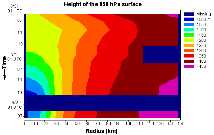
The
height of the 850-hPa surface remains
steady through 01 UTC 1 September
when rapid height falls begin in the
inner 25 km. Outside
the
inner core, the height gradient
increases throughout the time
period. The
plot shows that Elena reached
its maximum intensity, in terms of
minimum 850 hPa height, ~20 UTC 1
September.
<>
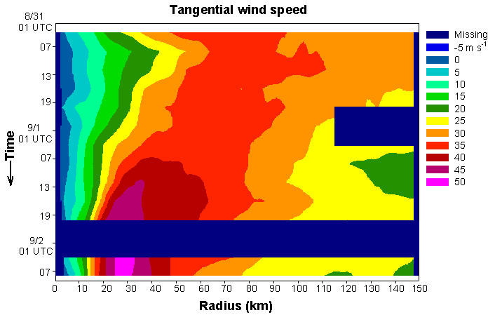
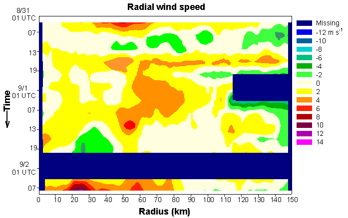
The
maximum tangential wind speed moves
radially inward from 70 to 25 km. The wind speed
increases rapidly starting 07
UTC 1 September as does the gradient of
tangential wind within 25 km of
the eye. Peak
intensity at 850 hPa is
between 03 and 07 2 September, well
after the best track peak intensity
at 18 UTC 1 September.
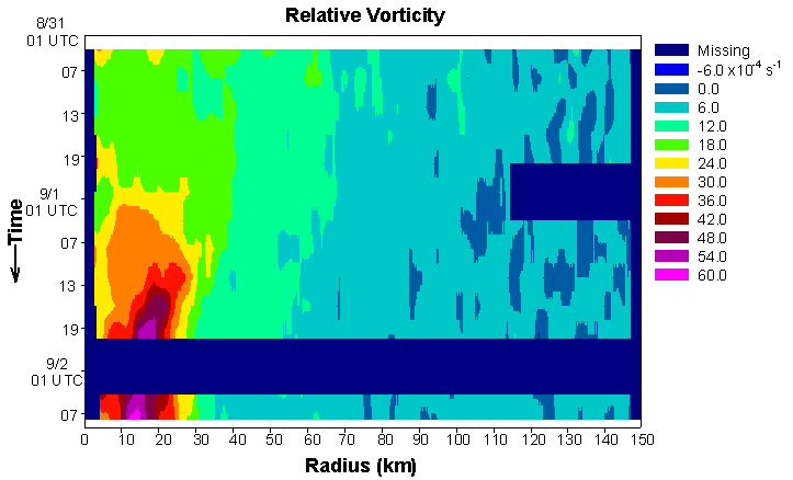
Little
change in the radial distribution of
relative vorticity occurs until
Elena starts to rapidly intensify around
01 UTC 1 September.
After this time, the vorticity
grows within
the eyewall in a narrow (5-7 km) ring
around the eye to greater values
than 60 x 10-4
s-1.
Throughout
Elena’s intensification, the inner 150
km is dominated by outflow at
850 hPa. Weak
inflow is seen
intermittently, and only from 13 - 19
UTC 1 September reaching the
inner core. Given
the upward motion seen
in the figure below, strong inflow must
have been confined below the 850-hPa
level.
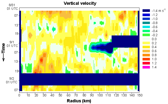
Much of
the inner 150 km of Elena is covered
with upward motion throughout the
storms intensification.
A strong eyewall
updraft channel is seen beginning ~07 UTC
1 September. The
very strong downdraft
centered on 100 km between 01 and 07 UTC
1 September is a real feature,
whose existence remains unexplained as
of yet.
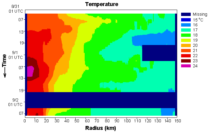
The
warmest temperatures at 850 hPa within
the eye of Elena occur between
07 and 13 UTC 1 September, 12 hours
before peak intensity.
This is possibly due to the
raising of the height of
the inversion in the eye with
intensification of the storm.
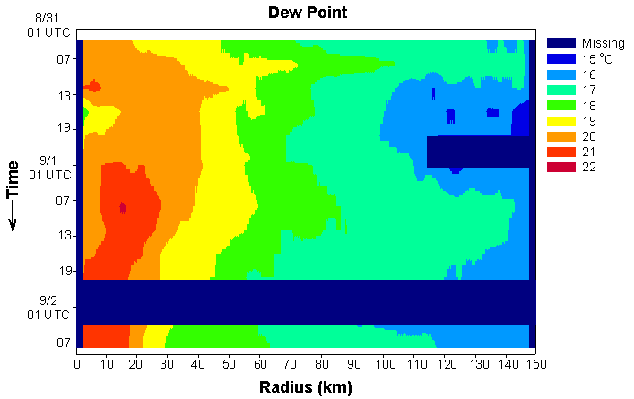
Very
little change occurs to the dew point in
Elena with time, except within
50 km of the center where the values and
gradient increase, especially
after 01 UTC 1 September.
The region of
maximum dew points begins in the eyewall
and moves radially inward with
time, eventually spanning the entire
region from the eye to the eyewall.
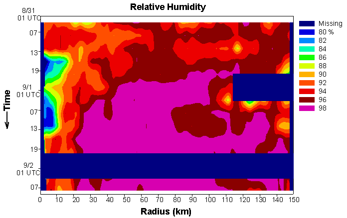
A
minimum in relative humidity exists
within the eye of Elena for 24
hours between 13 UTC 31 August and 13
UTC 1 September, after which the
relative humidity sharply increases
within the eye due to lower
temperatures and higher dew points
possibly due to eye/eyewall mixing. Outside the
eye, relative humidities exceed
98% over much of the inner 150 km.
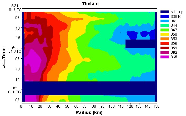
Most of
the changes in the distribution of theta
e in Elena occur within the
inner 50 km. Maxima
in theta e occur in
the eyewall and eye of Elena between 07
and 13 UTC 1 September, and
again in the eye from 19 UTC 1 September
through 07 UTC 2 September. The radial
gradient of theta e is maximized in
the eyewall and moves radially inward
with time.