 Shown
below is a time series of the percent of area covered by >30 and
>40 dBZ
within 75 km of the center of Elena, constructed in order to
investigate
changes in the areal coverage of convection within the storms core.
Shown
below is a time series of the percent of area covered by >30 and
>40 dBZ
within 75 km of the center of Elena, constructed in order to
investigate
changes in the areal coverage of convection within the storms core.
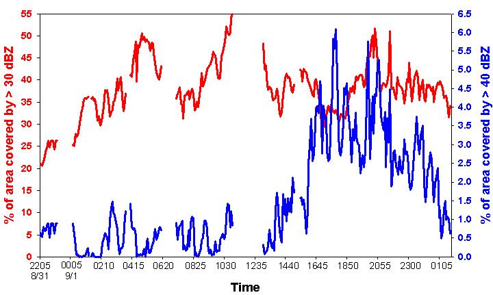
 The red line and left scale is the
percentage of area
covered by >30 dBZ, while the blue line and scale to the right
represent the
area covered by >40 dBZ. Breaks in
the time series represent times without radar data.
The percent of area covered by >30 dBZ steadily increases
with
time to a peak value of 55% by 11 UTC 1 September.
During the same time period, the area covered by >40 dBZ
shows
several spikes, but shows no upward trend and averages ~.75%. After 13 UTC, the area covered by >30 dBZ
decreases slightly and remains steady around 40% through 02 UTC 2
September. However, the area covered by
>40 dBZ
undergoes a dramatic increase in the same 12-hour period.
A sharp increase begins ~16 UTC and the peak
in coverage (~6%) occurs at 18 UTC, after which the coverage of deep
convection
decreases steadily until the end of the period of study.
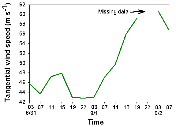
This increase and then peak in the coverage
of deep convection within Elena’s core is coincident with the rapid
intensification and maximum tangential wind speeds (from 850 hPa flight
level
recon data) found in Elena, shown below.
The red line and left scale is the
percentage of area
covered by >30 dBZ, while the blue line and scale to the right
represent the
area covered by >40 dBZ. Breaks in
the time series represent times without radar data.
The percent of area covered by >30 dBZ steadily increases
with
time to a peak value of 55% by 11 UTC 1 September.
During the same time period, the area covered by >40 dBZ
shows
several spikes, but shows no upward trend and averages ~.75%. After 13 UTC, the area covered by >30 dBZ
decreases slightly and remains steady around 40% through 02 UTC 2
September. However, the area covered by
>40 dBZ
undergoes a dramatic increase in the same 12-hour period.
A sharp increase begins ~16 UTC and the peak
in coverage (~6%) occurs at 18 UTC, after which the coverage of deep
convection
decreases steadily until the end of the period of study.
This increase and then peak in the coverage
of deep convection within Elena’s core is coincident with the rapid
intensification and maximum tangential wind speeds (from 850 hPa flight
level
recon data) found in Elena, shown below.
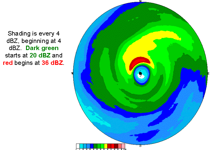
Analysis of the radar
images from Apalachicola, FL
shows that the increase in deep convection was not symmetric about
Elena’s
center. Rather, it was concentrated in
the northern eyewall, as the long-term time averaged radar reflectivity
plot
shows below (averaged 1310-2355 UTC 1 September).
To
quantify the changes in deep convection in various quadrants of Elena,
time
series of the percent of area covered by >40 dBZ within 75 km of the
center
were constructed with respect to both true geography and the direction
of
vertical wind shear. In the graph
below, the “NW” (“NE”) quadrant represents the 90° wedge directly to the left (right) of due
north.
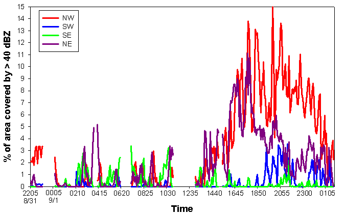
Concentrating
now on only the time period after 13 UTC, it is clear to see that the
increase
in area covered by >40 dBZ is primarily coming from the northern
half of
Elena’s circulation. The NW quadrant
shows the largest increase (15%) and remains high even after the
percentage in
the NE quadrants starts to drop off.
The SW quadrant shows a modest increase in coverage after 19 UTC
while
deep convection in the SE quadrant is almost non-existent through the
time
period.
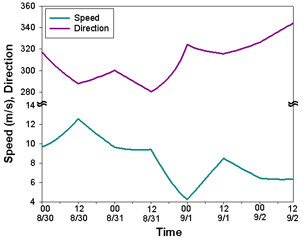 With respect to vertical wind shear, the
quadrants
are oriented such that the division between quadrants lies along the
shear
vector, or that “downshear left” represents the 90° wedge counterclockwise from directly
downshear to
left of the shear vector. As can be
seen below, the direction of vertical wind shear in Elena was from the
northwest throughout the period of study.
With respect to vertical wind shear, the
quadrants
are oriented such that the division between quadrants lies along the
shear
vector, or that “downshear left” represents the 90° wedge counterclockwise from directly
downshear to
left of the shear vector. As can be
seen below, the direction of vertical wind shear in Elena was from the
northwest throughout the period of study.
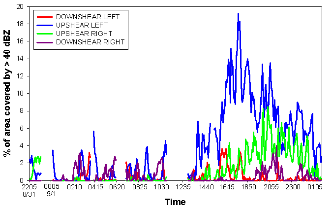
Again
looking at only the time period after 13 UTC, the increase in the
coverage of
deep convection is initially confined to the upshear left quadrant,
with a
later increase in coverage in the upshear right quadrant as the
convection
seems to rotate cyclonically around the storm with time.
Small peaks in the coverage are seen in the
other two quadrants, but overall the areal coverage of deep convection
in the
downshear quadrants remains low.