The Great Map Storm of 2015
Antecedant Conditions
AO, EPO, and PNA Teleconnection Patterns (Positive Phase)
AO Telleconnection Pattern (ESRL)EPO Telleconnection Pattern (ESRL)
PNA Telleconnection Pattern (ESRL)
NH Mean and Anomaly Geopotential Heights (1 Nov 2014 - 27 Jan 2015)
300 hPa Mean Height (ESRL)300 hPa Height Anomalies (ESRL)
850 hPa Mean Height (ESRL)
850 hPa Height Anomalies (ESRL)
Time Series
San Fransisco, CA 90-day Precipitation (CPC)Blue Canyon, CA 90-day Precipitation (CPC)
Albany, NY 90-day Temperature (CPC)
North American Means and Anomalies
850 hPa Mean Heights (ESRL)850 hPa Height Anomalies (ESRL)
300 hPa Mean Heights (ESRL)
300 Height Anomalies (ESRL)
850 hPa Mean Temperature (ESRL)
850 hPa Temperature Anomalies (ESRL)
700 hPa Mean Temperature (ESRL)
700 hPa Temperature Anomalies (ESRL)
January 26-27 Blizzard/Nor'Easter
North America - Master Loops (Alicia Bentley)North Pacific - Master Loops (Alicia Bentley)
North Atlantic - Master Loops (Alicia Bentley)
North America - 310K (Alicia Bentley)
North America - 295K (Alicia Bentley)
Pacific - 310K (Alicia Bentley)
Pacific - 295K (Alicia Bentley)
Atlantic - 310K (Alicia Bentley)
Atlantic - 295K (Alicia Bentley)
Kyle Griffin's Maps (Kyle Griffin)
HRRR Frontogenesis Analyses (Philippe Papin)
North America IR Satellite (Philippe Papin)
New England Radar Mosaic courtesey of Philippe Papin (College of Dupage)
500 hPa Vorticity D(prog)/Dt (Kyle Griffin)
12 UTC 25 Jan 2015 (Kyle Griffin)12 UTC 26 Jan 2015 (Kyle Griffin)
12 UTC 27 Jan 2015 (Kyle Griffin)
Sanders, F., 1988: Life History of Mobile Troughs in the Upper Westerlies (AMS. Mon. Wea. Rev., 116, 2629-2648.)
Select Figures from Sanders (1988)
Radar Imagery (UCAR RMMM)
Importance of probabilistic forecasting (Lee Grenci)
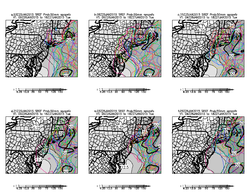
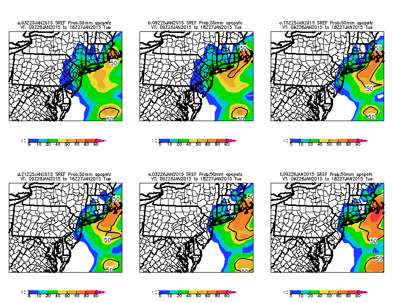
SREF-generated areal snowfall probabilities for the Northeast
Russ Schumacher's 10%-90% snowfall forecast MAP post
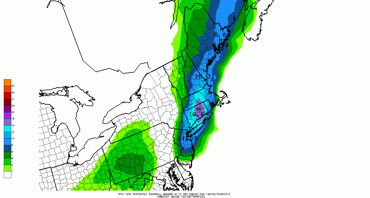
10th Percentile Snowfall Forecast (WPC)
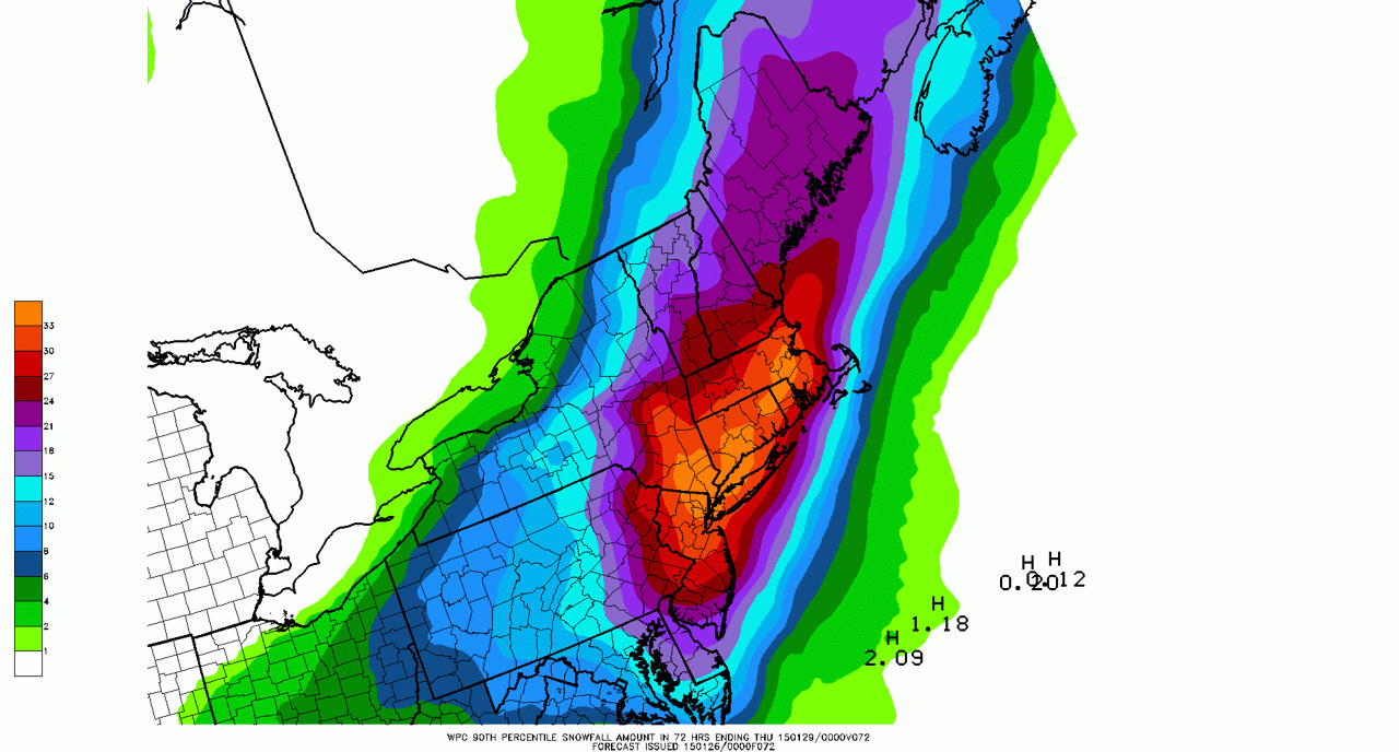
90th Percentile Snowfall Forecast (WPC)
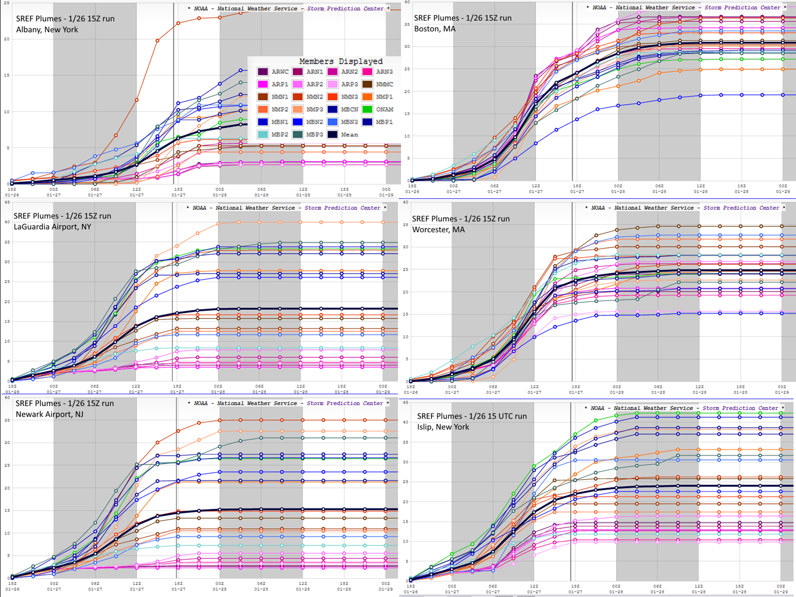
SREF Plume Forecast MAP Post (Dan Lindsey and Cliff Mass)
SREF Plumes from 1500 UTC 26 Jan 2015 NOAA NWS/SPC
Ensemble Forecasting Technique (Anton Seimon & Jimmy Correia)
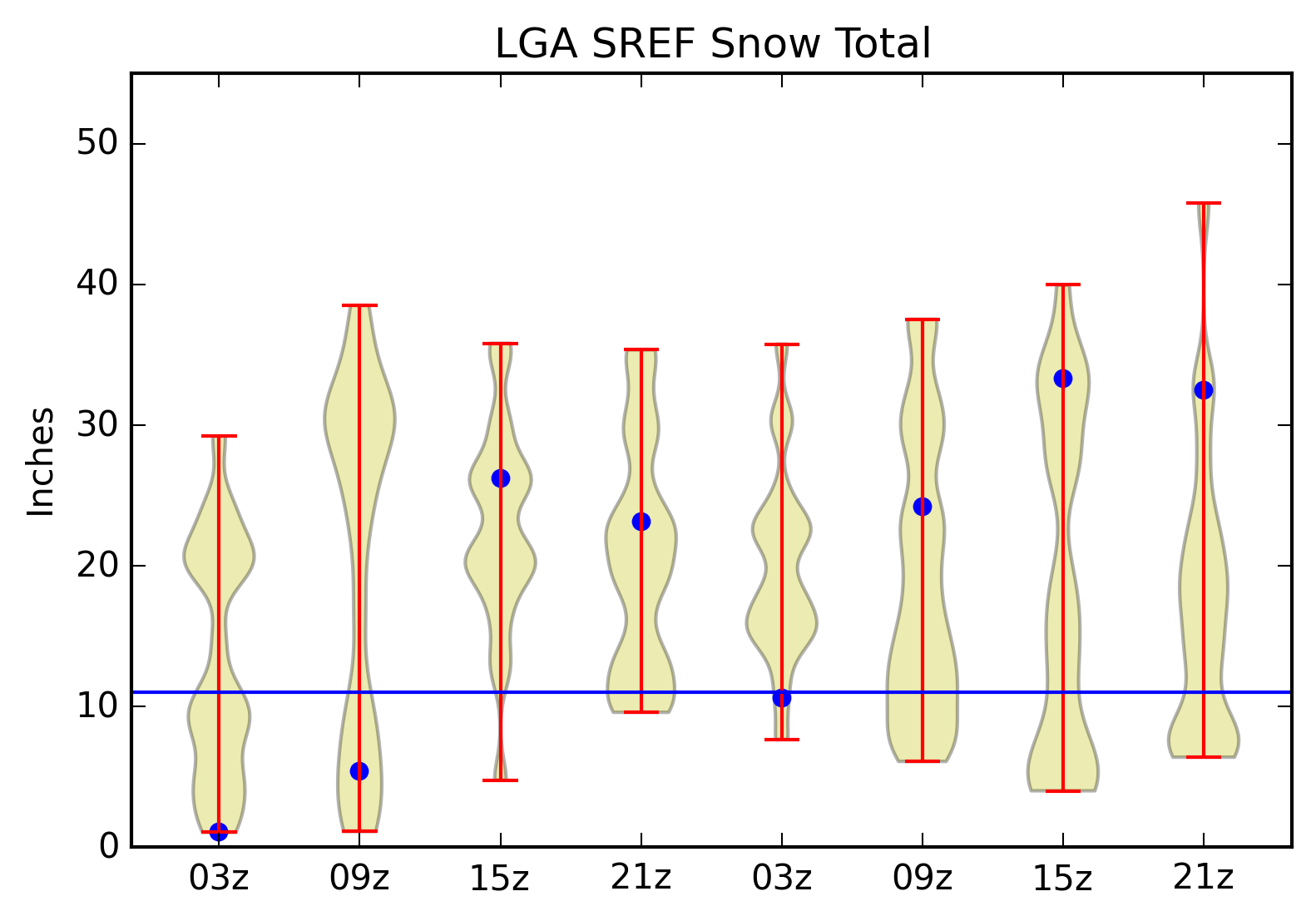
Violin Plots of SREF Snowfall Forecast
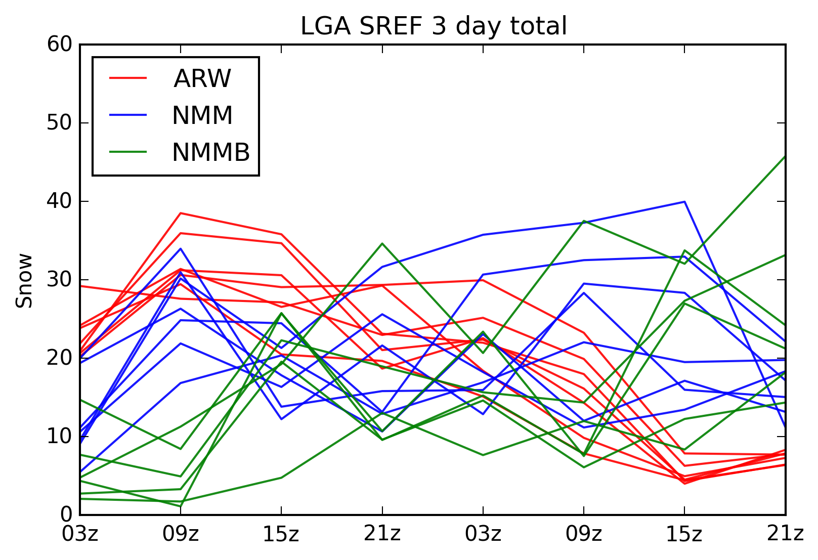
SREF 3-Day Snowfall Forecast
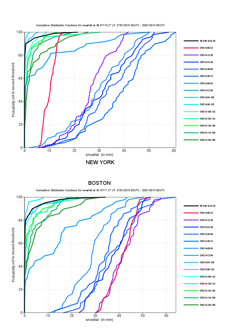
Tim Hewson's addendum to the above MAP post and description of his ECMWF Forecast & Reforecast Cumulative Probability Function plot
Con-Way truck traffic on 27 Jan and 20 Jan
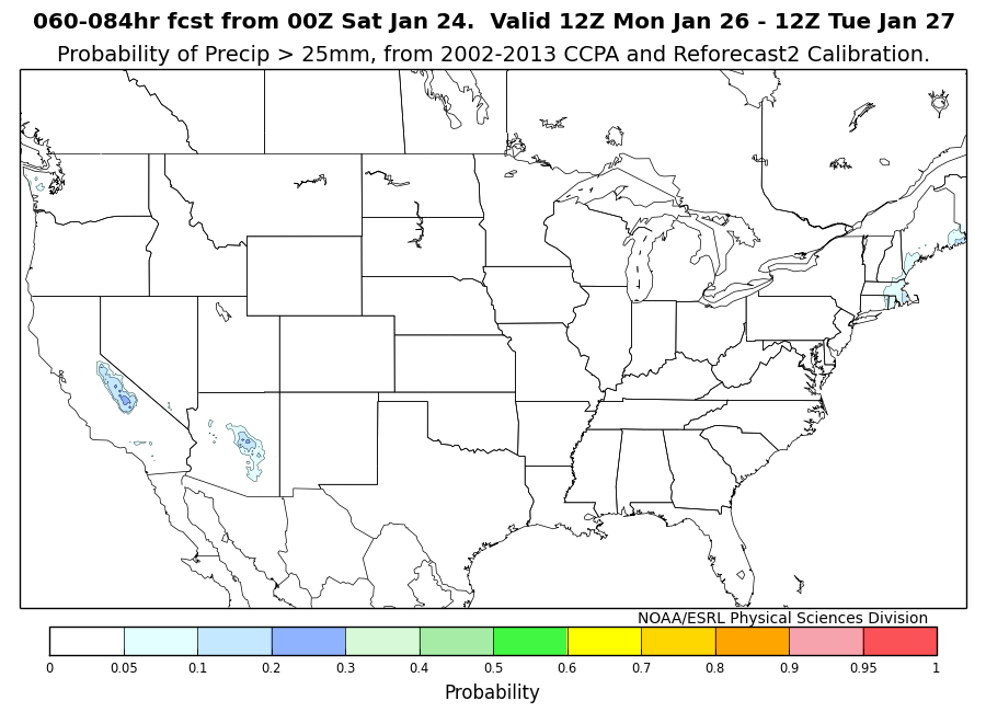
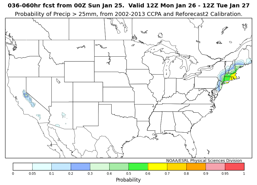
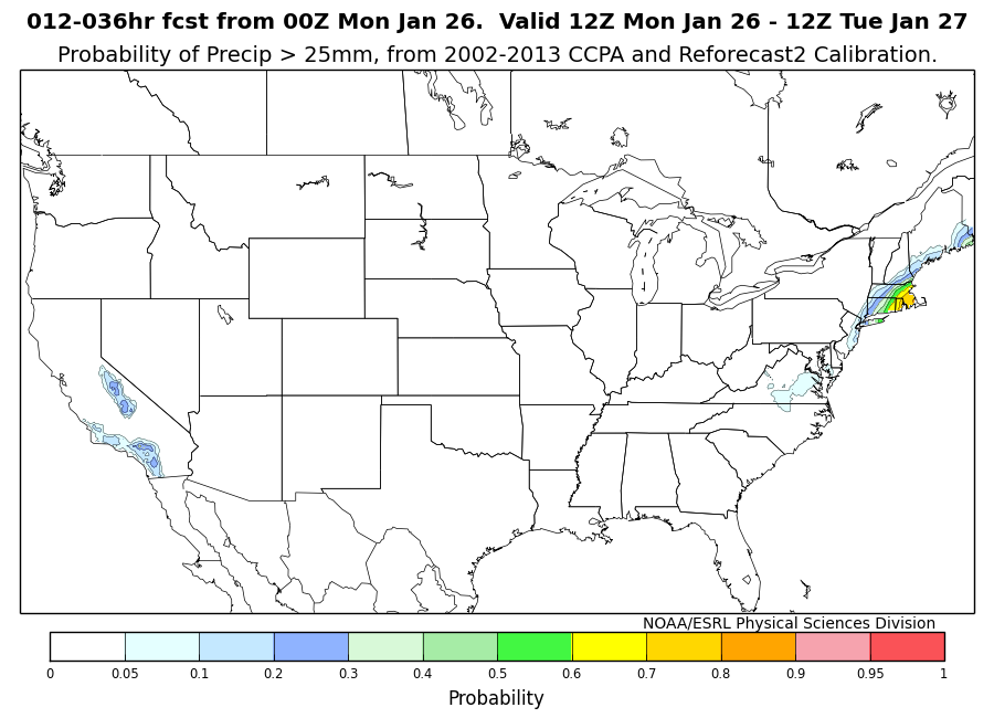
GEFS Climatologically Calibrated Precipitation Analysis (CCPA) probabilities for 060-084hr forecast, 036-060hr forecast , and 012-036hr forecast.
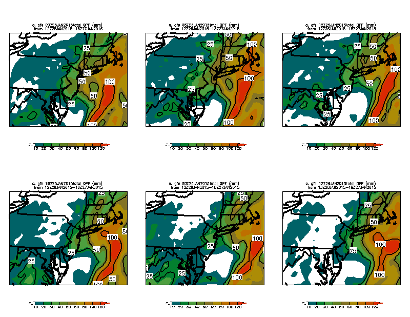
GEFS Ensemble Mean QPF vs. M-Climate for 120hr forecast, 96hr forecast , 72hr forecast , and 48hr forecast
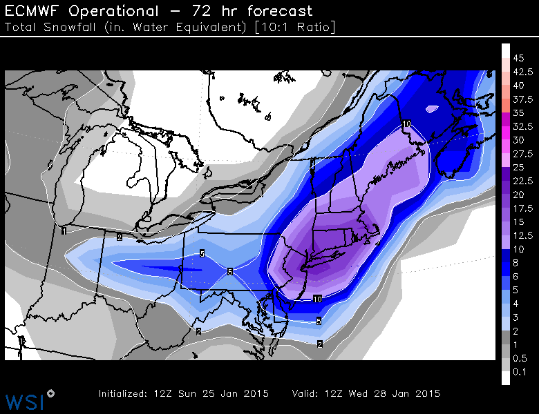
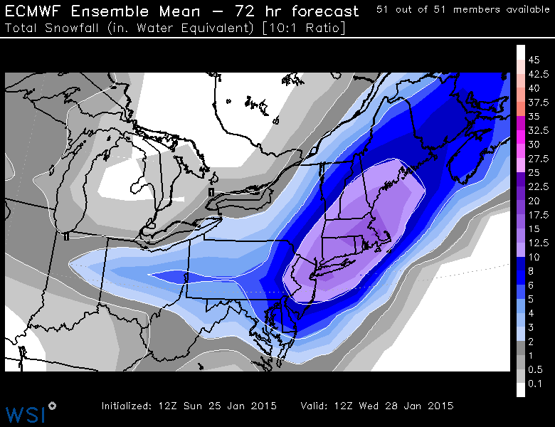
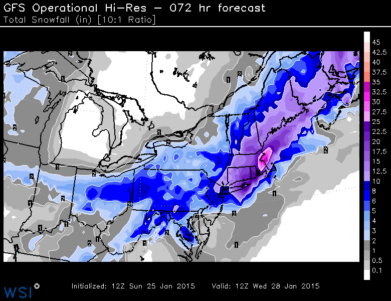
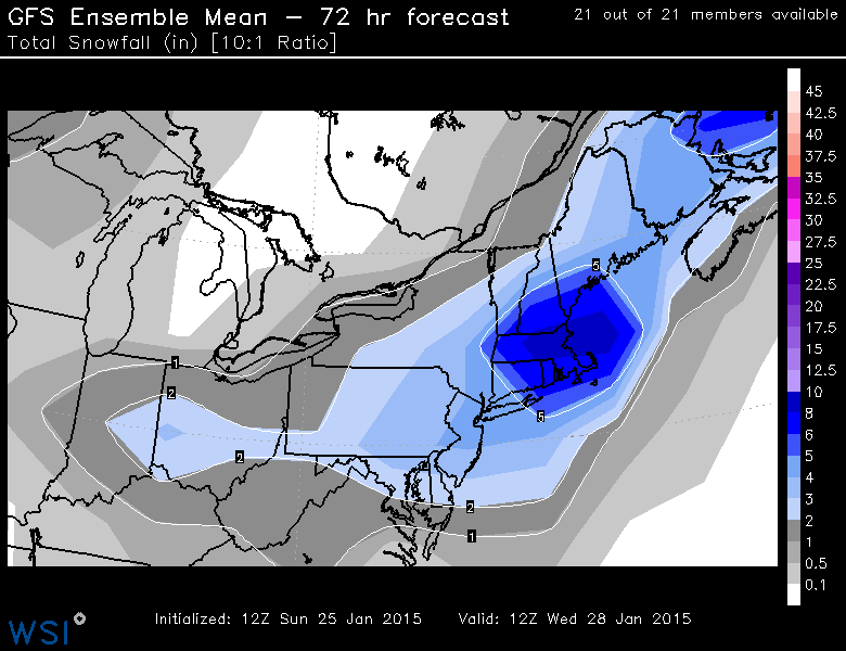
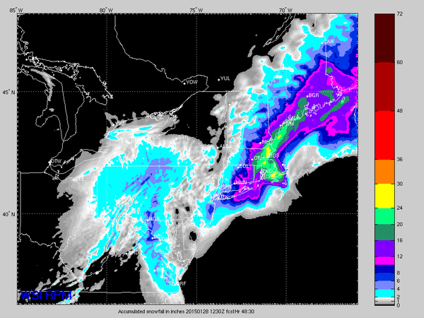
72-hour Snowfall Accumulation forecasts (Courtesy of Michael Ventrice) from the ECMWF Deterministic Run, the ECMWF ensemble mean , the GFS Deterministic Run , the GFS Ensemble Mean , and WSI's RPM model
Greg Carbin's Historical METAR analysis on MAP
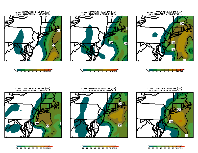
D(prog)/D(Time) of QPF from GFS, NAM , SREF , SREF fill
"ECMWF forecasts for US east coast snow storm 27 January 2015 - a tale of two cities" (ECMWF)
Additional Model Data Archive and Model Cycle Comparisons
NAM 4km 00UTC 20150127 - 850 hPa Temperature (WxBell)Model Total Precip. Comparison (00UTC 20150125) (WxBell)
Model Total Precip. Comparison (12UTC 20150125) (WxBell)
Model Total Precip. Comparison (00UTC 20150126) (WxBell)
Model Total Precip. Comparison (12UTC 20150126) (WxBell)
Euro Ensembles MSLP and Low Locations (12UTC 20150126) (WxBell)
Model Total Precip. Comparison (00UTC 20150127) (WxBell)
February 1-3 Potential Winter Storm
North America - Master Loops (Alicia Bentley)North Pacific - Master Loops (Alicia Bentley)
North Atlantic - Master Loops (Alicia Bentley)
Kyle Griffin's Maps (Kyle Griffin)
Isentropic Analysis (Earl Barker)
GEFS Ensemble Forecast (Ross Lazear)
Other Miscellaneous Products
SPC Meso ArchiveSPC Meso Archive
National Snow Analyses - NOHRSC
World Climate Index Map
Mike Ventrice's TRMM Precipitation / MJO Filtered VP200 hPa / 200 hPa Winds
Wyoming Sounding Page
Twister Data
National Buoy Data Center
Storm Prediction Center Meso-analysis
Penn State's EWALL Model Page
High Resolution Rapid Refresh Home Page
Kyle Griffin's Maps: Main Page
Ron-Mctaggart Cowan's DT Maps and Coupling Index
Heather Archambault's 2013 GFS Analyses
Tom Galarneau's Real Time Diagnostics
RAP-UCAR Real-Time Weather Data
Digital Typhoon - Typhoon Images and Information
PSD Maproom - ESRL
NeXt Generation Weather Lab - College of DuPage
Free Relief Maps
Modis Satellite Imagery World Viewer
Levi Cowan Tropical Tidbits
NCAR-RAL TC Guidance Project
Bob Hart's Model Page
Climate Reanalyzer (UMaine)
DAES In the News


Related Links
-
Department of Atmospheric and Environmental Sciences
University at Albany,
State University of New York -
DAES - ES351
1400 Washington Avenue
Albany, NY 12222
PHONE (518) 442-4556
FAX (518) 442-5825
-
- Faculty/Staff Directory
- Visit our Facebook site
