|
Potential Impacts of Long-term
Drought on Congo Rainforest |
||||
|
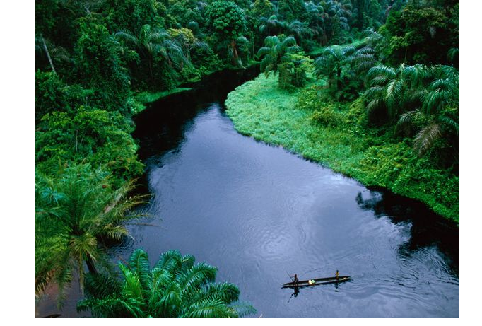
(Waterways
are highways in the depths of the Congo rainforest) |
||||
|
|
·
Press release ·
News and views (in hundreds; few samples listed
below)
·
The authors would like to provide answers to several
frequently asked questions about this research What is the major
finding of this research? We found a
widespread decline in satellite-measured vegetation greenness in the
Congo rainforest in the past 10-13 years, and this large-scale forest
browning is
generally consistent with the gradual temporal changes in moisture,
vegetation and climate parameters observed from several independent satellite
sensors (optical, thermal,
microwave and gravity). What
is the implication of the finding? The severe short-term
droughts that occurred recently in Amazonia in 2005 and 2010 have drawn broad
attention to the vulnerability of tropical forests to climatic disturbances.
Previous studies have focused mostly on short-term drought effects on
Amazonian forests while little attention has been paid to African rainforest,
let alone to the impacts of long-term drought on the forests. Our finding relates directly to
the growing concerns of future climate change on rainforests in the tropical
regions where most climate models project increasing drought under global
warming. Under the stress of an increased severity of water deficit in a
warmer and drier 21st century climate, the gradual loss of photosynthetic
capacity and water content over a long period may alter forest species
composition and structure and thus affect biodiversity and carbon storage of
tropical rainforests. For example, drier conditions may favor deciduous trees
at the expense of evergreen trees. Why were remote sensed data primarily used? Systematic monitoring
of the forests is essential to understanding their response to climate
change, and remote sensing remains the only viable way of synoptically and
repeatedly monitoring vast remote regions such as the Congo basin where in situ observations are very limited.
This is probably the most comprehensive observational study thus far
exploring the effects of long-term drought on Congolese rainforest using
several independent satellite sensors over the Congo Basin What is satellite
measured vegetation greenness? Vegetation
greenness measures vegetation vigor of plant life. It is often quantified as
a vegetation index (a single number) calculated from solar radiation
reflected back to remote sensors at different spectral bands. It generally
correlates well with in situ photosynthesis and chlorophyll content.
Hence higher greenness values relate to increased presence of chlorophyll in
the vegetation being monitored. Satellite measured vegetation indices
such as enhanced vegetation index (EVI) used in this study are radiometric
measures of photosynthetically active radiation
absorbed by canopy chlorophyll and are therefore good surrogate measures of
the physiologically functioning surface greenness level in a region. They
allow us to study the seasonality of vegetation growth, measure vegetation
health, and detect climatic impacts such as drought and flooding on
vegetation. EVI is found to be especially useful in high biomass tropical
broadleaf forests like in the Congo Basin. What is
vegetation browning? Under
drought conditions, the water deficit stress on trees will be manifested as
less turgid leaves, and if the stress is beyond some threshold, the trees may
drop their leaves. This behavior can be detected as a decline in vegetation
greenness or EVI. A slow decline of EVI over time implies loss of
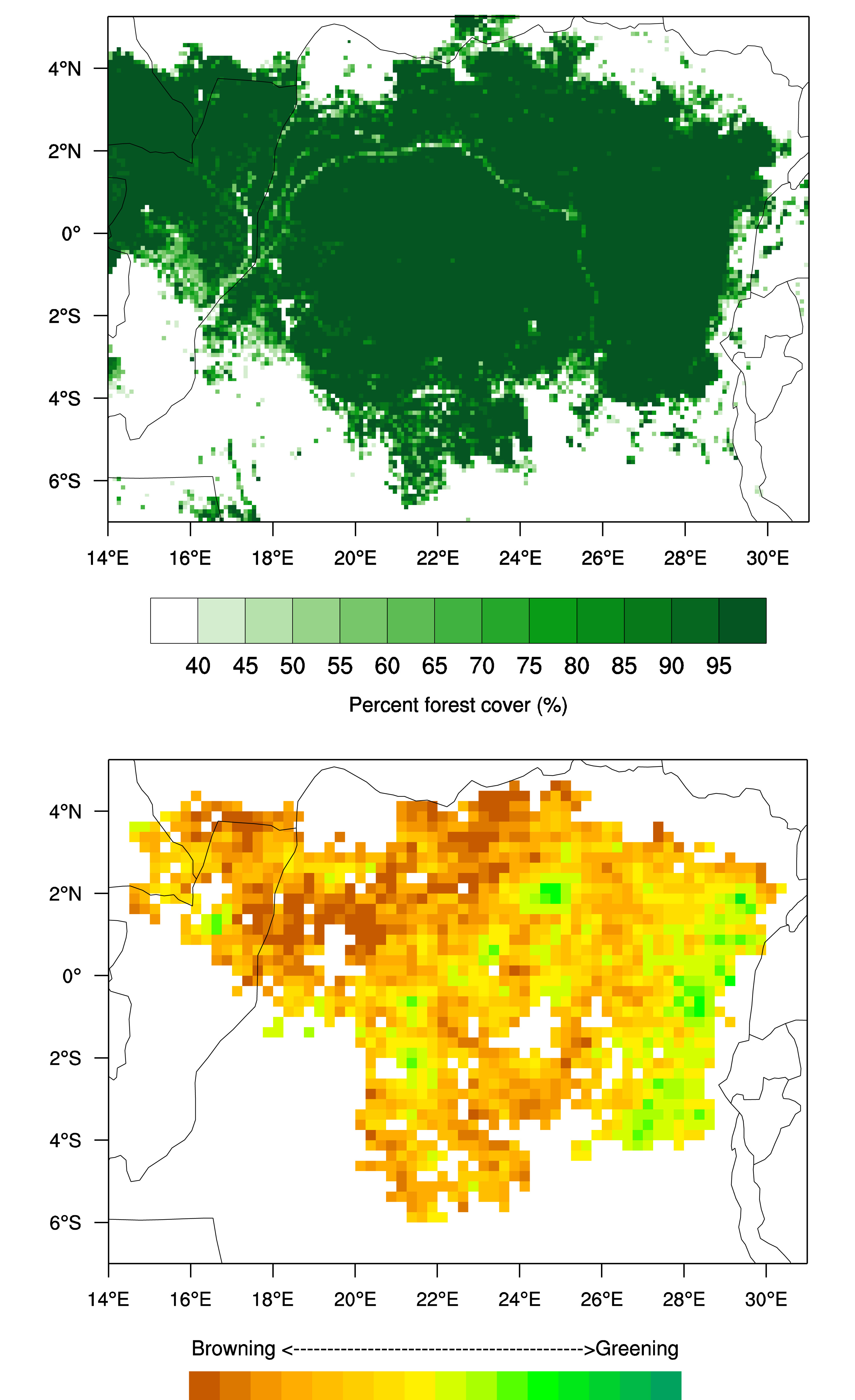
photosynthetic capacity, which is referred to as vegetation browning. Why did you study the African rainforest? The central
African rainforest, the second-largest on Earth, has experienced a long-term
drying trend whose impacts on vegetation dynamics remain mostly unknown
because in situ observations are
very limited. Why did you choose the Congolese rainforest
instead of the entire African rainforest? The African
rainforests span the equatorial region by nearly seven degrees from north to
south, but some forested regions such as in West Africa have extensive cloud
and aerosol contaminations on satellite measured vegetation indices. We focus
our study only on the intact forested region in the Congo Basin (5° N–6° S,
14° E–31° E) as
this region has high-quality satellite measured vegetation greenness data. Why did you focus your analysis during a
three-month period in April–May–June? This period
represents the first of two rain and peak growing seasons and exhibits the
highest percentage of forested area with high-quality satellite measured
vegetation greenness data. What are major
differences in drought between Amazonian and Congolese rainforests? The
Amazonian forests have experienced two short-term and very intense droughts
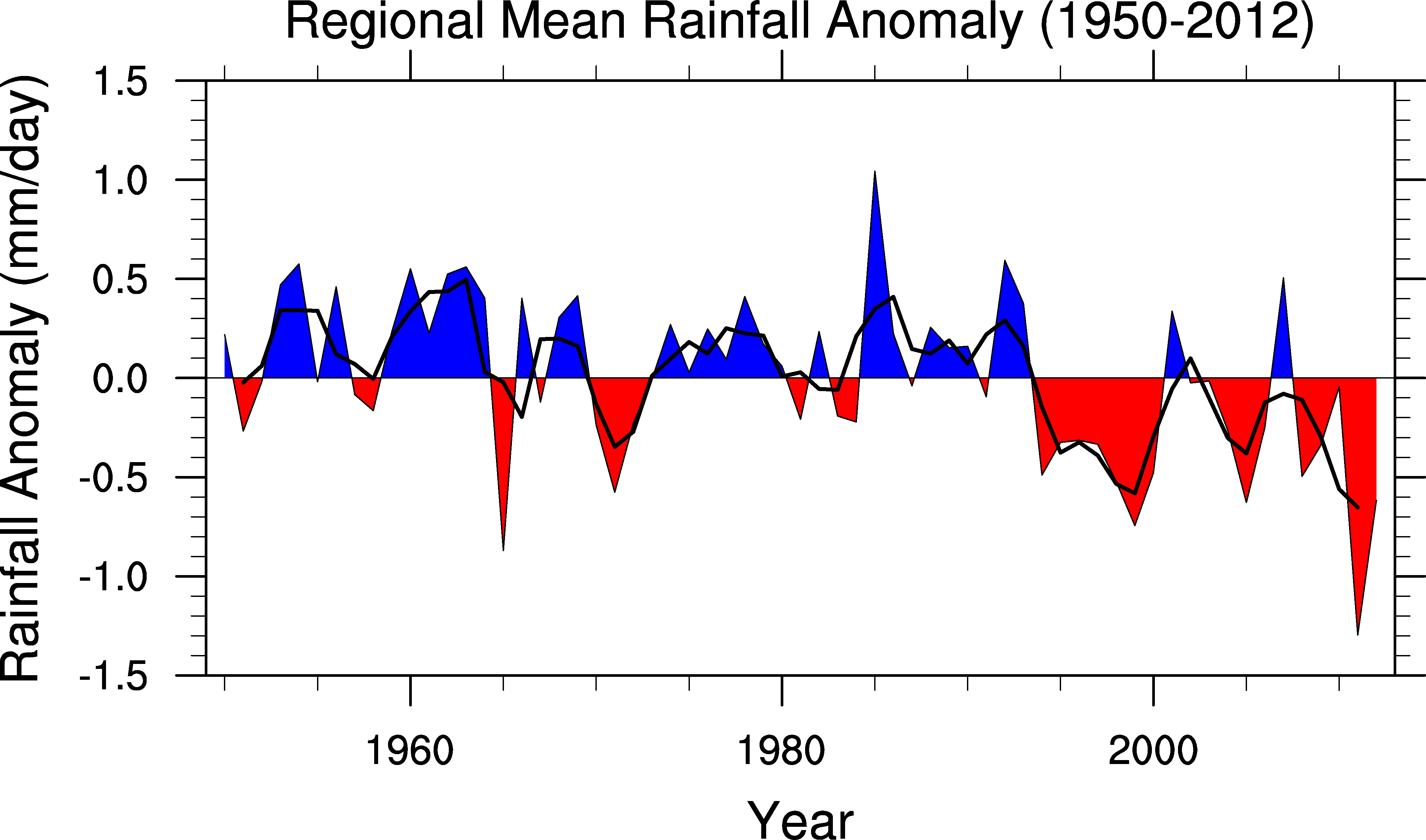
in 2005 and 2010. In contrast, the Congolese forests have experienced
long-term and gradual rainfall reduction. What are major
differences in drought impacts on Amazonian and Congolese rainforests? There
is a gradually decreasing trend in the Congolese rainforest greenness and
water content, suggesting a slow adjustment to the long-term drying trend.
That’s in contrast to the more rapid response in the Amazon such as
large-scale tree mortality brought about by the two more episodic drought
events. Did you see
large-scale tree mortality in the Congolese rainforest? Nope. We analyzed two other vegetation parameters
derived from active and passive microwave satellite sensors and also examined
high-resolution Landsat images. Our results only show small and
gradual changes in vegetation water content and canopy structure, rather than
large-scale tree mortality as observed recently in the Amazon. The small and
gradual changes in the Congolese forest are consistent with the gradual
changes in rainfall and moisture in the Congo Basin. Why did you
attribute the
large-scale browning to the long-term drying trend? The widespread
decline in vegetation greenness, particularly in the northern Congolese forest,
is generally consistent with decreases in rainfall, terrestrial water
storage, water content in aboveground woody and leaf biomass, and the canopy
backscatter anomaly caused by changes in structure and moisture in upper
forest layers. It is also consistent with increases in photosynthetically
active radiation and land surface temperature. These multiple lines of
evidence indicate that this large-scale vegetation browning, or loss of
photosynthetic capacity, may be, at least partially, attributable to the
long-term drying trend. What are the
major uncertainties of this study? It
is important to keep the
following points in mind when interpreting our results. First,
although we have paid much attention to ensuring high-quality vegetation greenness
data used in our analysis, satellite
products do contain errors and noise. Uncertainties also exist in rainfall
data due to lack of adequate ground observations over tropical rainforests. Furthermore,
the effects of long-term drought on vegetation are more complex than severe
short-term drought and thus are less obvious and difficult to observe. Second, we use statistical approaches
to quantify the association between vegetation parameters and moisture and
climate variables. However, a
statistical correlation, no matter how strong, does not imply causality. Also
most of satellite data used in
the study are only 10-13 years long, which limits our understanding of
vegetation-climate interactions and our attribution of the large-scale
browning. Therefore,
further detection and attribution of drought impacts on tropical forests
require long-term ground observations and drought manipulative experiments as
done for the Amazon forests; these, however, are not available for the
Congolese forest and should be a research priority. Third,
we express the change of most variables as a linear trend per decade. This is
just one simple way to quantify the interannual
variations in vegetation and climate variables while reducing the
year-to-year data noise. The estimated trend only applies to the study region
and to the study period, and thus should not be extrapolated into other
regions or over longer periods. In summary, remote
sensing data, like all scientific observations, have uncertainties. As stated
at the beginning of our paper, the impact of changes in precipitation
patterns, such as short-term and long-term droughts, on tropical rainforests
is poorly understood and currently under debate. We hope that our paper will
promote such debate and more research. Advances in science
require new observations, rigorous and transparent analyses. This study
provides evidence that hopefully will contribute to our understanding of how
tropical forests respond to drought. However, different plant species show
different responses to climate change. It’s important to note that our
assessment is just one first step and full consideration of the vast and
complex range of processes affecting different tropical rainforest species is
needed to fully assess future resilience of tropical forests. What will you do
next? Understanding complex interactions between climate change and tropical
rainforests is a critical, exciting and challenging research topic. We are now expanding our
analyses to other forests and searching for more data, particularly long-term
ground observations, to
understand the physical processes and mechanisms driving the complex
vegetation-climate interactions. Other relevant
news about droughts and rainforests Drought
strikes the Amazon rainforest again http://www.nature.com/news/2010/101029/full/news.2010.571.html Climate change crisis for rainforests http://www.nature.com/news/2009/090305/full/news.2009.136.html Drought could have lasting effect on trees, specialist says http://www.purdue.edu/newsroom/outreach/2012/120719PurcellTrees.html Severe drought has lasting effects on Amazon http://www.nature.com/news/severe-drought-has-lasting-effects-on-amazon-1.12129 April-23-2014 |
|||