Dynamic Processes and Mechanisms of Weather Systems and Troposphere-Stratosphere Coupling
Research
The research of our group involves a multiscale perspective of the dynamics of weather systems and troposphere-stratosphere coupling. These interests stem for our goal to fully understand
the dynamical processes and mechanisms that shape the middle and high latitude tropopause on weather to subseasonal timescales. The structure and evolution of the tropopause is governed by
processes on a vareity of time scales from the mesoscale and synoptic (e.g., jet/front circulations, gravity waves, weather systems) to subseasonal (e.g., stratospheric circulation changes).
The projects below address a variety of issues related to weather systems, tropopause and upper troposphere-lower stratosphere dynamics, and troposphere-stratosphere coupling.
Current Research
CSTAR: NWS-UAlbany collaborative research
Visit the UAlbany CSTAR webpage here.
Applying Forecast Track and Intensity Diagnostics to High-Impact Northeast Winter Storms
With Profs. Kristen Corbosiero and Ryan Torn NOAA Award #NA16NWS4680005 (2016-2019)
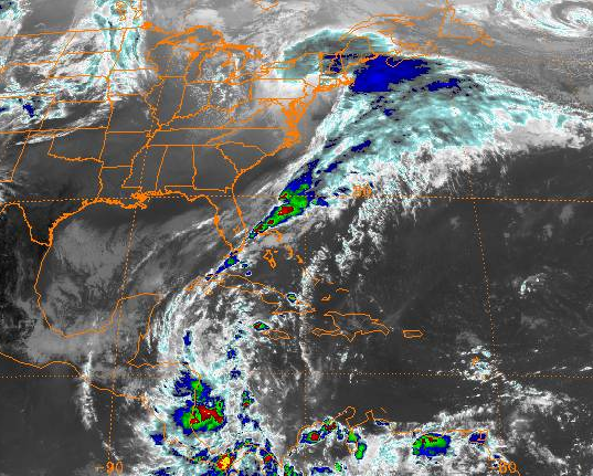
1800 UTC 29 Oct 2011 IR satellite of a transition season Nor'easter
A common forecasting "rule of thumb" is that as lead-time decreases, numerical weather prediction models exhibit a westward trend in the forecast position of low-pressure systems along the East Coast of the United States. This westward trend, which may turn so called "fish storms" into high-impact weather events for the northeastern U.S., is sometimes attributed to the representation of diabatic processes downstream of the trough associated with the incipient cyclone. Specifically, it is commonly believed that the underrepresentation of diabatic heating at longer lead times prevents a forecast from producing the negative tilt of the trough, and collapse of the half wavelength between the cyclone and downstream ridge, that is commonly observed. Other possibilities are that models have systematic errors in low-level baroclinic processes or the speed of the jet, which in turn give rise to errors in the position of the various precursor features.
The perceived westward forecast trend has not been systematically verified, and its potential root causes have not been investigated. It is, thus, the objective of this project to formally evaluate this forecasters' rule of thumb and improve the situational awareness of medium range forecasts of high-impact winter storms.
Subseasonal-to-Seasonal Timescales and Troposphere-Stratosphere Coupling
During the winter season troposphere-stratosphere coupling provides a mechanism for the stratosphere to influence the troposphere on subseasonal timescales. Stratosphere-troposphere coupling can manifest itself as a stratospheric regime change or, in extreme cases, a sudden stratospheric warming (SSW). On subseasonal timescales, SSWs have been linked to extreme weather and climate, such as cold air out breaks and negative Arctic Oscillation (AO), which can impact the U.S., Europe and Asia. However, an open question in understanding the mechanisms of troposphere-stratosphere coupling involves identifying the role of the synoptic scale in the dynamical communication between the troposphere and stratosphere.
Understanding the role of the stratosphere in subseasonal-to-seasonal variability and predictability of Arctic weather systems ONR Award #N000141812199 (2018-2023)
For a variety of reasons, small but intense cyclones are very poorly predicted over the Arctic even by the most skillful NWP models. The inability to predict this forcing is a predictability barrier that must be overcome if intra- and interseasonal predictions of sea ice are to become a reality. This project considers the precursors to some of the most intense Arctic cyclones, known as tropopause polar vortices (TPVs), and the predictability of these TPVs at subseasonal lead times.
This project is a contribution to the broader efforts of the Office of Naval Research Department Research Initiative (ONR-DRI) on Overcoming the Barrier to Extended Range Prediction over the Arctic. You can read more about the ONR-DRI on the public facing page I maintain for the DRI here.
A climatological and forecast perspective on the lower stratospheric environment during synoptic waveguide perturbation events NSF Award #1547814 (2016-2019)
This research will demonstrate linkages between synoptic events that result in both Rossby wave amplification within the tropopause waveguide and troposphere-stratosphere coupling that occur in the Northern Hemisphere cool season. The outcome of the proposed research has the potential to advance scientific understanding by:
investigating noteworthy synoptic and sub-synoptic scale processes that contribute to the establishment of a lower stratospheric environment conducive for troposphere-stratosphere interaction; and
establishing a synoptic-scale perspective for understanding and interpreting the large-scale dynamic processes associated with troposphere-stratosphere interaction.
By focusing on synoptic scale events that perturb the tropopause waveguide and categorizing these events based on type and timing with respect to stratospheric vortex variability, the results of this research will advance our knowledge of the currently not-well-understood role of synoptic scale processes in the coupled evolution of the troposphere-stratosphere system.
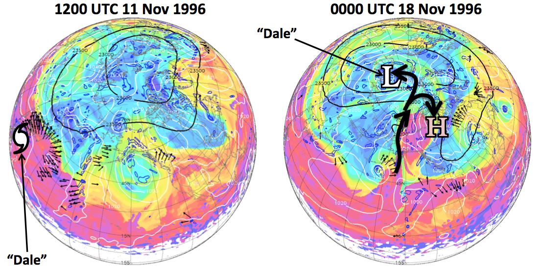
The dynamic tropopuase potential temperature (fills), irrotational wind (vectors),
mean sea level pressure (white), 10-hPa geopotential height (black) at 1800 UCT 11 Nov 1996 (left)
and 0000 UTC 18 Nov 1996 (right).
Our work considers synoptic systems, like tropical cyclones, that can impact the tropopause-level flow and thus have a potential impact on troposphere-stratosphere coupling. Our research also considers explosive cyclogenesis events and other mechnisms of high-latitude wave breaking near the tropopause.
A Categorical Assessment of Forecast Skill, Uncertainty, and Biases in Extended-Range Ensemble Forecasts of Stratospheric Regime Changes NOAA Award #NA16OAR4310068 (2016-2019)
The main scientific objective of this work is to evaluate whether a categorical assessment of errors and uncertainty associated with physical (thermodynamic) processes in the troposphere lead to an improved understanding of sources of biases in the stratospheric forecasts initialized prior to a stratospheric regime changes.
This project is a contribution to the broader efforts of NOAA's Subseasonal-to-Seasonal (S2S) Prediction Task Force and the SPARC-Statospheric Network for the Assessment of Predictability (SNAP). You can read more about the S2S Prediction Task Force here and more about SPARC-SNAP here.
Previous Research
Transition season Northeast storms and East Coast atmospheric rivers
With Prof. Dan Keyser, contributed to the UAlbany-NWS CSTAR collaborative research effort. Visit the UAlbany CSTAR webpage in NOAA/VLAB for more info. NOAA Award #NA13NWS4680004 (2013-2017)
Transition season storms, have the potential to cause substantial societal and economic disruptions, and are particularly difficult to forecast.
Widespread power outages and transportation delays often
result during the autumnal and vernal transition seasons when trees are likely to be in full leaf,
making them highly susceptible to breakage under windy conditions or under the weight of
heavy wet snow and/or ice. When atmospheric systems traditionally associated with the tropics (e.g., subtropical jets and
atmospheric rivers) interact with the extratropical flow, the potential exists for robust surface
cyclogenesis.
Motivated by the scientific and operational challenges of improving the understanding
and prediction of tropical-extratropical interactions, our project addressed the following forecast
problems applicable to the Northeast US:
The synoptic-to-mesoscale atmospheric conditions in
the extratropics occurring prior to, and during, the development of transition season storms, with emphasis on the formation and maintenance of lower-tropospheric cold pools;
The role of tropical moisture transport occurring within atmospheric rivers in the formation and evolution of transition
season and winter season storms.
The key takeaway results are now avaialble for training in the NOAA VLab environment via the NWS-UAlbany VLab page
Tropopause Jet Dynamics
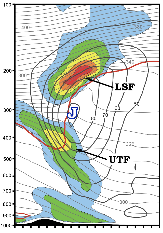
The consideration of the separate evolution of the lower stratospheric and upper tropospheric frontal zones (Fig. below) associated with a tropopause jet-front system can lead to a
better understanding of the comprehensive life-cycle of a jet streak through a midlatitude baroclinic wave.
A vertical cross section through a tropopause jet-front system. Where LSF → Lower Stratospheric Front, UTF → Upper Tropospheric Front, J → Jet
Though the governing dynamics for the development of the upper
tropospheric and lower stratospheric fronts was the same (tilting frontogenesis), the upper tropospheric and lower stratospheric fronts develop asynchronously within the
evolution of a tropopause jet-front system through the northwesterly and southwesterly flow portions of a baroclinic wave.
In the course of the examination of the northwesterly
and southwesterly flow case studies, it was evident that geostrophic temperature advection in the lower stratospheric cyclonic shear portion of the jet-front system provided a
favorable environment for Sawyer-Eliassen circulations above the jet core. In northwesterly flow, the resulting circulations weakened an initially intense lower
stratospheric front, which corresponded with a decrease in the slope of the tropopause above the jet core. This occurred in concert with the development of an intense upper
tropospheric front, which provided a precursor disturbance for a robust mid-continental surface cyclogenesis event.
The analysis suggested a pathway linking the lower stratospheric structure to sensible weather at the surface.