1 Sep
6 Sep
8 Sep
9 Sep
15 Sep
20 Sep
22 Sep
27 Sep
29 Sep
4 Oct
6 Oct
11 Oct
13 Oct
18 Oct
20 Oct
21 Oct
25 Oct
27 Oct
1 Nov
3 Nov
8 Nov
10 Nov
15 Nov
17 Nov
18 Nov
22 Nov
29 Nov
30 August
You can find a copy of the syllabus HERESome links for the first classes:
- Clausius-Clapeyron Equation: https://www.e-education.psu.edu/meteo300/node/584
A brief review of the equations and the two figures. We will also get aquatinted with the Skew T-log p diagram to illustrate useful aspects of the C-C equation. - Atmospheric Thermodynamics: http://www.ecmwf.int/sites/default/files/Atmospheric_Thermodynamics.pdf
by Peter Bechtold, ECMWF, May 2015 - Precipitable Water: https://en.wikipedia.org/wiki/Precipitable_water
NOAA (SoS) Science on a Sphere: http://www.spc.noaa.gov/exper/soundingclimo/
- Center for Western Weather and Water Extremes (CW3E)
Integrated Water Vapor (IWV), Integrated Water Vapor Transport (IVT), and time-integrated IVT: http://woodland.ucsd.edu/?page_id=491 - Rasmussen (1967): http://www.atmos.albany.edu/daes/atmclasses/atm509/papers/Rasmussen_1967.pdf
Integrated Water Vapor Transport Definition: (IVT):
- Atmospheric Rivers: http://www.esrl.noaa.gov/psd/atmrivers/
- Atmospheric River Portal: http://mead.ucsd.edu/
Other Links for Today's Class
-Alicia Bentley’s Real-time GFS maps
-Tropical Cyclone Rainfall Data (WPC – David Roth)
-NHC Rainfall pdf (TCs before 1956):
-The Great Long Island-New England Hurricane of 1938
-Track of Hurricane Hazel (1954)
-Hurricane Hazel event overview (NWS)
-Hurricane Hazel (1954) 60th anniversary
-Hurricane Hazel (1954) and extreme rainfall in southern Ontario
-[PPT] A Comparison of Three Memorable Tropical Cyclones: Sandy (2012), Hazel (1954), and the “38 Hurricane”
-[PDF] Bosart and Carr - 1978 - Monthly Weather Review
1 September
Presentation Used for the Class
Useful links:
Forecasting Overview:
-Weather Prediction Center (WPC) QPF Page:http://www.wpc.ncep.noaa.gov/qpf/qpf2.shtml
---Excessive Precipitation Outlooks:http://www.wpc.ncep.noaa.gov/html/fam2.shtml#excessrain
---WPC Verification Page:http://www.wpc.ncep.noaa.gov/html/hpcverif.shtml
Real-Time Forecast Data Hubs
--Weatherbell: http://models.weatherbell.com/
--Tropical Tidbits: http://www.tropicaltidbits.com/analysis/models/
--College of Dupage: http://weather.cod.edu/forecast
--Pivotal Weather: http://pivotalweather.com/
--Tomer's Maps: http://www.atmos.albany.edu/student/tburg/analysis/
--Alica's Maps: http://www.atmos.albany.edu/student/abentley/realtime.html
--NCAR Convection Permitting Ensemble: http://www.image.ucar.edu/wrfdart/ensemble/index.php
Real-Time Observational Data
--SPC Mesoanalysis: http://www.spc.noaa.gov/exper/mesoanalysis/
--SPC Sounding Page: http://www.spc.noaa.gov/exper/soundings/
----Sounding Climatology: http://www.spc.noaa.gov/exper/soundingclimo/
--Radar Data from College of Dupage: http://weather.cod.edu/satrad/
--Satellite Data from NASA: http://weather.msfc.nasa.gov/GOES/goeseastconus.html
Archive Rainfall Image Sources
--Multi-Radar Multi-Sensor System (MRMS): http://nmq.ou.edu/
-----User guide to use MRMS: http://www.wdtb.noaa.gov/courses/MRMS/ProductGuide/index.php
--NCAR Radar Image Archive: http://www2.mmm.ucar.edu/imagearchive/
--Russ Schumacher's 50-yr Extreme Precip Event Archive:http://schumacher.atmos.colostate.edu/precip_monitor/50y24h/event_images/year_list.php
--David Roth's TC Precipitaton Archive: http://www.wpc.ncep.noaa.gov/tropical/rain/tcrainfall.html
--GIOVANNI Visualizations: http://giovanni.gsfc.nasa.gov/giovanni/
Downloadable Precipitation Datasets
Stage IV Precipitation Data (4km Resolution) 2002-Current:
--http://data.eol.ucar.edu/cgi-bin/codiac/fgr_form/id=21.093
--GRIB format
--Only for the United States
PERSIDAN-CDR (0.25 degree resolution) 1983-2016:
--http://www.ncdc.noaa.gov/cdr/atmospheric/precipitation-persiann-cdr
--NetCDF format
--Global Data (60N-60S)
TRMM-TMPA Data (0.25 degree resolution) 2000-2014:
--http://disc2.gesdisc.eosdis.nasa.gov/data/TRMM_RT/TRMM_3B42RT.7/
--NetCDF format
--Global Data (60N-60S)
IMERG Data (0.1 degree resolution) 2014-Current:
--http://gpm1.gesdisc.eosdis.nasa.gov/data/GPM_L3/GPM_3IMERGHH.03/
--HDF format
--Global Data
Other Downloadable Datasets
--Iowa State Archive Data Page:http://mesonet.agron.iastate.edu/archive/
--NCEP Data Product Repository:http://www.nco.ncep.noaa.gov/pmb/products/
--NOMADS: http://nomads.ncep.noaa.gov/
--GridSat Satellite Imagery:http://www.ncdc.noaa.gov/thredds/catalog/cdr/gridsat/files/
--Archive NWS Watches/Warnings: https://mesonet.agron.iastate.edu/request/gis/watchwarn.phtml
--Our local data, find via DAES Wiki:https://wiki.albany.edu/display/daes/Data
---- To log in, use the same username/password combination as your linux username/password.
6 September
Links for class:
-
Timelapse video of a microburst in Columbus, Ohio:
-
New York Times: Flooding of Coast, Caused by Global Warming, Has Already Begun
Infographic: A Sharp Increased in "Sunny Day" Flooding
- Tampa Bay, FL Sounding - 1800 UTC 1 Sep 2016
- Tallahassee, FL Sounding - 0000 UTC 2 Sep 2016
8 September
Links for class:
-
Doswell et al. (1996): Flash Flood Forecasting: An Ingredients-Based Methodology
---More papers by Chuck Doswell
-
Chuck Doswell's Home Page
-
Chuck Doswell’s “Chuck Chatter”: Where Chuck sounds off on relevant topics in the field of meteorology
-
Murphy (1993): What is a Good Forecast: An Essay on the Nature of Goodness in Weather Forecasting
--Quote: “First, it should be understood that forecasts possess no intrinsic value. They acquire value through their ability to influence the value of decisions made by users of the forecasts”
-
Bosart and Carr (1978): A Case Study of Excessive Rainfall Centered Around Wellsville, New York, 20-21 June 1972
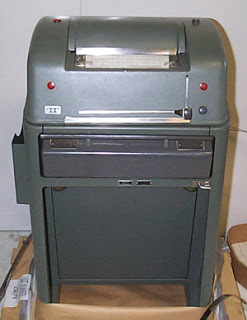
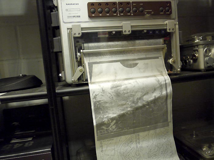
- Other links for todays class
- Old photos to illustrate how weather maps were formerly received

9 September (Makeup Class)
Links for class:
- Critical Success Index (CSI)
or Threat Score (TS), and Equitable Threat Score (ETS)
-
WPC Verification
-
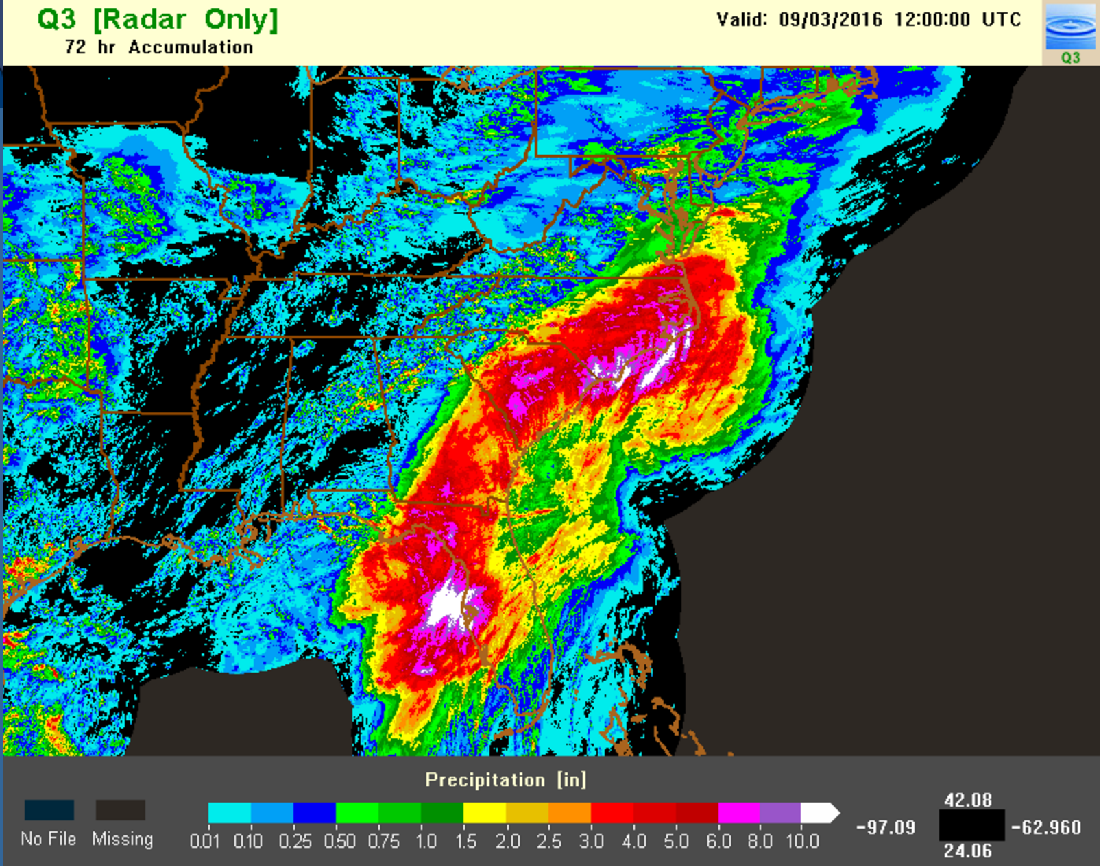
Hurricane Hermine Overview from NWS
--Rainfall Totals
--72h Totals Zoomed Out - 9-03-2016 from MRMS NMQ
13 September (No Class: Lance out of Town)
15 September (Ben Moore Lecture)
Links for class:Extreme Precipitation Events in the Central and Eastern US: Presentation by Ben Moore
Paper's Cited
--Corfidi et al. (1996): Predicting the Movement of Mesoscale Convective Complexes
--Doswell et al. (1996): Flash Flood Forecasting: An Ingredients-Based Methodology
--Maddox et al. (1979): Synoptic and Meso-Alpha Scale Aspects of Flash Flood Events
--Moore et al. (2012): Physical Processes Associated with Heavy Flooding Rainfall in Nashville, Tennessee, and Vicinity during 1-2 May 2010: The Role of an Atmospheric River and Mesoscale Convective Systems
--Peters and Schumacher (2014): Objective Categorization of Heavy-Rain-Producing MCS Synoptic Types by Rotated Principal Component Analysis
--Peters and Schumacher (2015): Mechanisms for Organization and Echo Training in a Flash-Flood-Producing Mesoscale Convective System
--Schumacher et al. (2011): Distant Effects of a Recurving Tropical Cyclone on Rainfall in a Midlatitude Convective System: A High-Impact Predecessor Rain Event
--Schumacher and Johnson (2005): Organization and Environmental Properties of Extreme-Rain-Producing Mesoscale Convective Systems
20 September
Links for class:
- Fred Sander's QG Theory Notes (password protected)
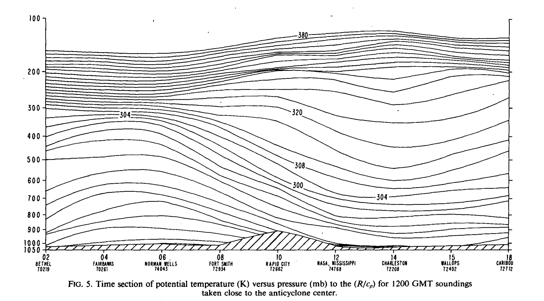
- Boyle and Bosart (1983): A Cyclone/Anticyclone Couplet over North America: An Example of Anticyclone Evolution
----Figure 5: Illustration of static stability changes associated with transition of cold to warm anticyclone - Effects of Divergence and Ageostropic Motion on Hydrostatic Stability: Lance Notes
22 September
Links for class:
- Refer to notes discussed in the previous class period on 20 Sep
- Refer to Sanders notes (pp. 3-7): http://www.atmos.albany.edu/daes/atmclasses/atm509/protected/Sanders_QG_Theory_MIT_Notes_July2014.pdf
- For HW#1, Lance referred to equations in Bluestein (1992) on pp. 178-179 and 379-385. You can find them here(password protected):
- Dynamic Tropopause pressure/wind d(prog)/dt (from Kyle Griffin's Page)
- 500-hPa height/vorticity/winds d(prog)/dt (from Kyle Griffin's Page)
- 700-hPa heights/temps/winds/PW d(prog)/dt (from Kyle Griffin's Page)
- Alicia Bentley's Synoptic Maps
- Center for Western Weather and Water Extremes (CW3E) IVT Plots
- Tom Galarneau's Real-Time Forecast QG Diagnostics Page
- Homework #1 Review: Answer Key (password protected)
Question #3 Figures: Figures For Q3 from HW#1 (password protected) - Center for Western Weather and Water Extremes (CW3E) IVT Plots
- Ben Moore's IVT Loop initalized with the GFS at 0600 UTC 4 Oct 2016
- Examples of Deforestation of Haiti in comparison to the Dominican Republic
- NASA Documents Haiti Deforestation
- Today's Lecture Presentation: Central American Gyres / Long Island Flooding
- Adiabatic: References - Bluestein Vol I (section 5.32) and Holton 4th edition (sections 3.5.2)
Lance's Class Notes on Adiabatic Vertical Motion Method (Password Protected)
Example in Bosart (1983)
- Kinematic: References - Blustein Vol I (section 5.3.1, pp. 313-316)
Lance's Class Notes on Kinematic Vertical Motion Method (Password Protected)
Example O'Handley and Bosart (1989)
-
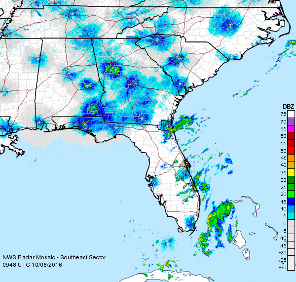
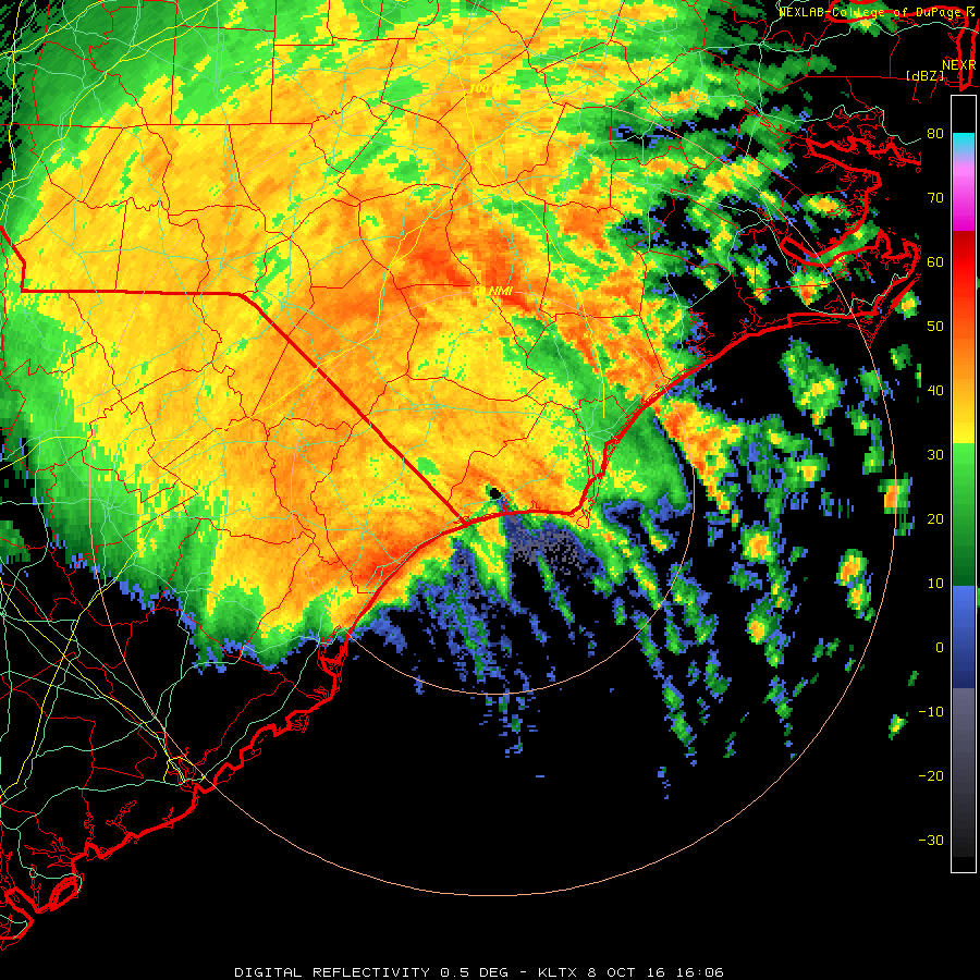
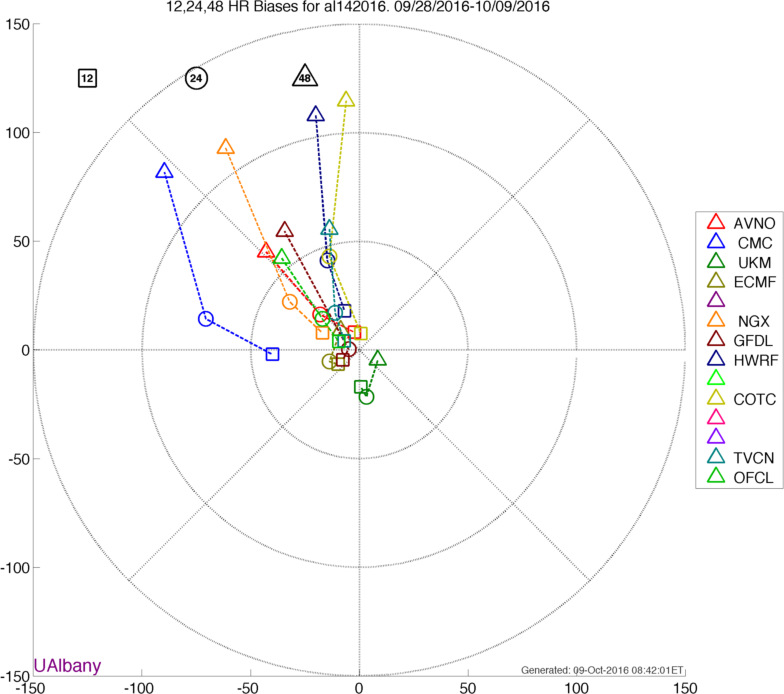
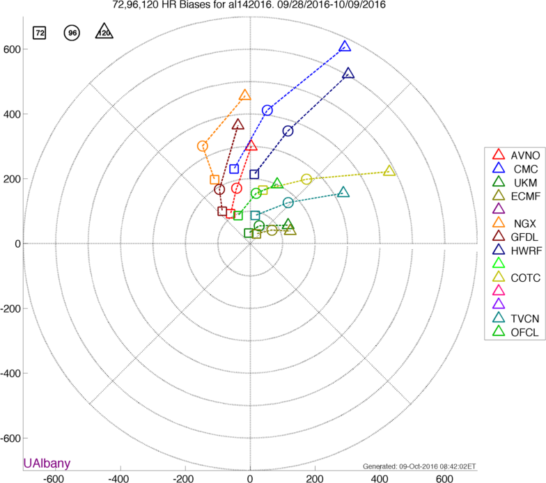
Rainfall Case Study: Hurricane Matthew
Alicia's Synoptic Maps
----Severe Weather Fields
----Tropical Transition Fields
----Standardized Anomalies
----Long radar loop of Matthew 6-9 October 2016
----Short radar loop of intense reflectivity band forming along coastal front 8 October 2016
----Differences in Ensemble Distribution of Matthew Track (Curtsey of Brian Tang)
----TC Track Bias 12-48 hours (Curtsey of Brian Tang)
----TC Track Bias 72-120 hours (Curtsey of Brian Tang)
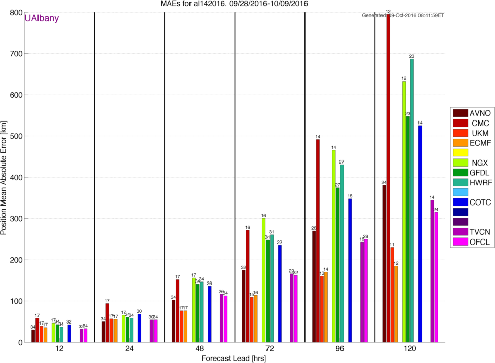
----Mean Absolute Error for Position by Forecast Lead
- Rainfall Case Study: Songda (2016) and the Pacific Northwest Windstorm
Alicia's Synoptic Maps
----Severe Weather Fields
----Tropical Transition Fields
----Standardized Anomalies
20 October
Links for class:
A Continuation of the lecture material that was started on 10/18
Different Methods of Computing Vertical Motion- Adiabatic: References - Bluestein Vol I (section 5.32) and Holton 4th edition (sections 3.5.2)
Lance's Class Notes on Adiabatic Vertical Motion Method (Password Protected)
Example in Bosart (1983)
- Kinematic: References - Blustein Vol I (section 5.3.1, pp. 313-316)
Lance's Class Notes on Kinematic Vertical Motion Method (Password Protected)
Example O'Handley and Bosart (1989)
- Lance's Class Notes on Thermodynamic Methods of Estimating Vertical Motion and Precipitation Rate (password protected)
- Carr and Millard (1985): A Composite Study of Comma Clouds and their Association with Severe Weather over the Great Plains
-
John Gyakum's illustration of different precipitation rates as a function of vertical motion and airmass type:
--Readme
----Precipitation Diagram During Montreal Ice Storm (1998)
----Precipitation Diagram During Slovenia Ice Storm (2014)
----Precipitation Diagram During Calgary Flood (2013) - Continuation of Material that was covered on Tuesday 25 Oct
- Realtime Streamlines via Earth nullschool
- Tom Galarneau's users guide to QG dynamics
----Tom Galarneau's QG dynamics page - Lance Class Notes on Orographic Influences (protected link)
- Lance Class Notes on Cancelation Problem in QG Omega Equation (protected link)
- Atmospheric Rivers over Eastern Canada: Their Seasonality, Impacts on Air Mass Dynamics, and Links to Extreme Precipitation (protected link)
--John Gyakum, Alice Wood, Eyad Atallah
21 October: Makeup Class
Links for class:
Refer to lecture material on 20 October
25 October
Links for class:
27 October
Links for class:
1 November
Links for class:
3 November
Links for class:
8 November
No Class (Lance Out of Town)
- Adiabatic: References - Bluestein Vol I (section 5.32) and Holton 4th edition (sections 3.5.2)
- Precipitation Processes Associated with Jet-Induced Vertical Circulations: Andrew Winters
- Lance's Class Notes: Water Vapor Budget
---Palmen and Newton Figures for Water Vapor Budget Notes - Alicia Bentley's Realtime Page
-
Lance's Class Notes: Water Vapor Budget
---Palmen and Newton Figures for Water Vapor Budget Notes - Fred Sanders QG Notes (Password Protected)
- Ben Moore's Realtime Integrated Vapor Transport Maps
- Center for Western Weather and Water Extremes (CW3E) IVT Plots
-
Case Studies:
--Snowzilla January 2016
--Super Typhooon Nuri November 2014 - World Rainfall Records
-
Topography of Southeast Asia/Taiwan
Zoomed in Topography of Taiwan
Orographic Precipitation: Taiwan (Typhoons Sepat and Wipha) - QPF Forecasting Exercise:
Overview of QPF Forecasting Activity
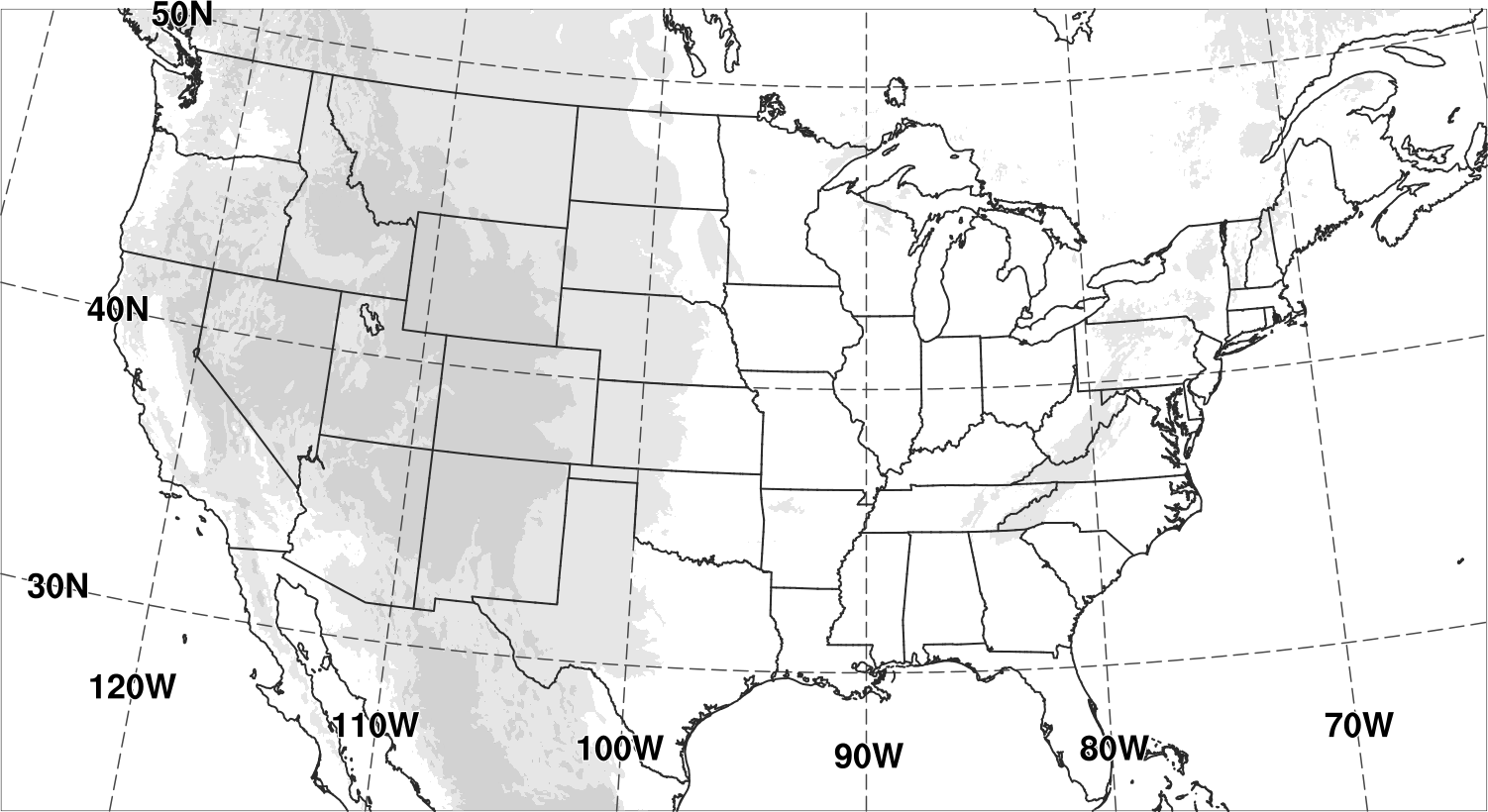
---Blank US Map with Topography (can print out out use when drawing on PowerPoint)
---Example of Composite Map and Forecast for QPF and Snowfall
Teams:
- Stefan Buchele
- Rachael Coons
- Brandon Currier
- Brian Feder
- William Flamholtz
- Wesley James
- Zubear Said
- Jonathan Blufer
- Dylan Card
- Shengzhe Chen
- Pamela Eck
- Lauriana Gaudet
- Wanhee Kim
- Tomer Burg
- Alexander Henny
- Macy Howarth
- Zach Murphy
- Kyle Pallozzi
- Vanessa Przybylo
- Massey Bartolini
- Eric Bunker
- Yuan Ming Cheng
- Meghan Conway
- Colleen McHugh
- Connor Nelson
- Adolfo Lugo Rios
- Multi-scale Interactions during the Winters of 2009-2010 and 2010-2011: A Link to the February 1979 Presidents' Day Storm: Bosart, Archambault, and Cordeira
-
Reflecting on the Presidents Day Storm 18-19 February 1979: Louis Uccellini
----Updated Presentation (Password Protected) - Southern Stream Storm 11-17 February 2003: Presidents Day Weekend Snow Storm: Grumm
- NH mean and anomaly maps before and after the Presidents’ Day II storm of 17–18 Feb 2003: NOAA/ESRL
-
Email from Andrea Lang: 29 Nov 2016
Supplemental Data
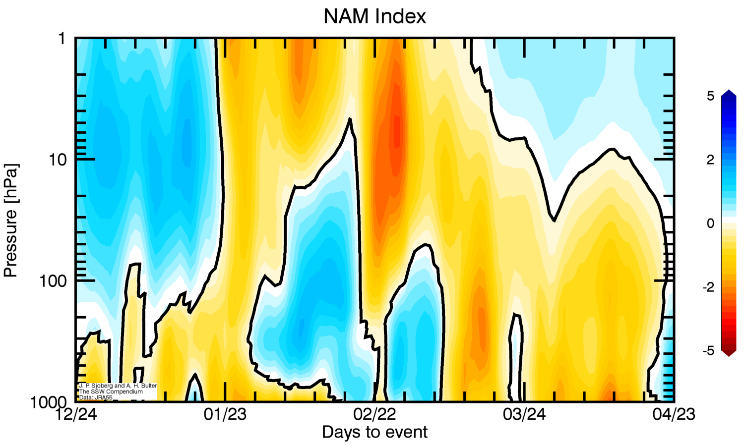
---Northern Annular Mode index for February 1979
---50-hPa Minimum Temperature (50-90N): 1979 MERRA2
---50-hPa Zonal Mean Zonal Wind (60N): 1979 MERRA2
---10-hPa Mean Zonal Wind (60N): 1979 MERRA2
---10-hPa Wave 2 Height Amplitude (60N): 1979 MERRA2
---50-hPa Wave 2 Height Amplitude (60N): 1979 MERRA2
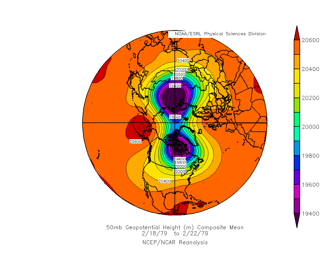
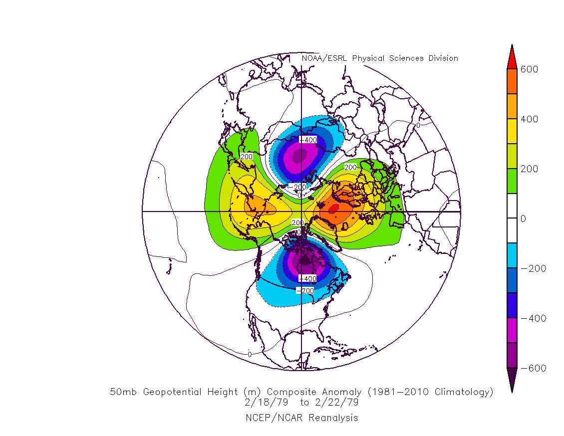
---50-hPa Geopotential Height: 18 Feb - 22 Feb 1979 NCEP/NCAR Reanalysis
---50-hPa Geopotential Height Anomaly: 18 Feb - 22 Feb 1979 NCEP/NCAR Reanalysis - Presidents' Day Storm I February 1979
Severe Weather Maps: Alicia Bentley
Tropical Transition Maps: Alicia Bentley
Standardized Anomaly Maps: Alicia Bentley - Presidents' Day Storm II February 2003
Severe Weather Maps: Alicia Bentley
Tropical Transition Maps: Alicia Bentley
Standardized Anomaly Maps: Alicia Bentley -
Title: A Diagnostic Analysis of the Presidents' Day Storm Of February 1979
Author: L. F. Bosart and S. C. Lin
Journal & Year: Monthly Weather Review - 1984 -
Title: Inclusion of a TKE Boundary Layer Parameterization in the Canadian Regional Finite-Element Model
Author: R. Benoit and J. Mailhot
Journal & Year: Monthly Weather Review - 1989 -
Title: Sensitivity of Model Simulations for a Coastal Cyclone
Author: I. Orlanski and J.J. Katzfey
Journal & Year: Monthly Weather Review - 1987 -
Title: Synergistic Interactions between an Upper-Level Jet Streak and Diabatic Processes that Influence the Development of a Low-Level Jet and a Secondary Coastal Cyclone
Author: L. W. Uccellini, R. A. Petersen, P. J. Kocic, K. F. Brill, and J. J. Tuccillo
Journal & Year: Monthly Weather Review - 1987 -
Title: The Presidents' Day Snowstorm of 18–19 February 1979: A Subsynoptic-Scale Event
Author: L. F. Bosart
Journal & Year: Monthly Weather Review - 1981 -
Title: Application of the 4-D McIDAS to a Model Diagnostic Study of the Presidents' Day Cyclone
Author: H. Hibbard, L. W. Uccellini, D. Santek, and K. F. Brill
Journal & Year: Bulletin of the American Meteorological Society - 1989 -
Title: Stratospheric–Tropospheric Mass Exchange during the Presidents' Day Storm
Author:P. Spaete. D. R. Johnson, and T. K. Schaack
Journal & Year: Monthly Weather Review - 1994 -
Title: Height Tendency Diagnostics Using a Generalized Omega Equation, the Vorticity Equation, and a Nonlinear Balance Equation
Author: J. Räisänen
Journal & Year: Monthly Weather Review - 1997 -
Title: A Model-Based Diagnostic Study of the Rapid Development Phase of the Presidents's Day Cyclone
Author: J. S. Whittaker, L. W. Uccellini, and K. F. Brill
Journal & Year: Monthly Weather Review - 1988 -
Title: A Technique for Diagnosing Three-Dimensional Ageostrophic Circulations in Baroclinic Disturbances on Limited-Area Domains
Author: A. F. Loughe, C.-C. Lai, D. Keyser
Journal & Year: Monthly Weather Review - 1995 -
Title: The Presidents' Day Cyclone of 18–19 February 1979: Influence of Upstream Trough Amplification and Associated Tropopause Folding on Rapid Cyclogenesis
Author: L. W. Uccellini, D. Keyser, C. H. Walsh, and K. F. Brill
Journal & Year: Monthly Weather Review - 1985 -
Title: The Presidents' Day Cyclone of 18–19 February 1979: Synoptic Overview and Analysis of the Subtropical Jet Streak Influencing the Pre-Cyclogenetic Period
Author: L. W. Uccellini, P. J. Kocin, R. A. Petersen, C. F. Walsh, and K. F. Brill
Journal & Year: Monthly Weather Review - 1984 -
Title: The Impact of Seasat-A Scatterometer Data on High-Resolution Analyses and Forecasts: The Development of the QE II Storm
Author: A. C. M. Stoffelen and G. J. Cats
Journal & Year: Monthly Weather Review - 1991 -
Title: Meteorological Precursors to the Explosive Intensification of the QE II Storm
Author: J. R. Gyakum
Journal & Year: Monthly Weather Review - 1991 -
Title: On the Evolution of the QE II Storm. I: Synoptic Aspects
Author: J. R. Gyakum
Journal & Year: Monthly Weather Review - 1983 -
Title: The Possible Influence of Upstream Upper-Level Baroclinic Processes on the Development of the QE II Storm
Author: L. W. Uccellini
Journal & Year: Monthly Weather Review - 1986 -
Title: On the Evolution of the QE II Storm. II: Dynamic and Thermodynamic Structure
Author: J. R. Gyakum
Journal & Year: Monthly Weather Review - 1983 -
Title: Analysis of the Impact of Seasat Scatterometer Data and Horizontal Resolution on GLA Model Simulations of the QE II Storm
Author: A. J. Lenzen, D. R. Johnson, and R. Atlas
Journal & Year: Monthly Weather Review - 1993
27 September
Links for class:
29 September
Links for class:
04 October
Links for class:
06 October
Links for class:
11 October: No Class (Yom Kippur)
13 October Midterm Exam
18 October
Links for class:
Different Methods of Computing Vertical Motion
10 November
Guest Lecture: Andrew WintersLinks for class:
15 November
Review of Homework#2
Solution Key for Homework #2 (Password Protected)
---Illustrations of using Skew-T's and maps for Homework#2 (Password Protected)
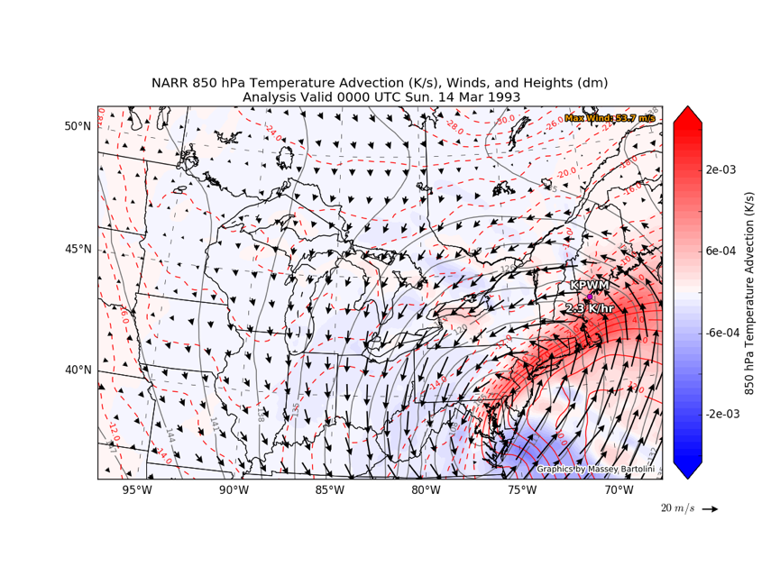
---Massey's Temperature Advection Map For Question#2a
Links for class:
17 November
Exam #2 Given
18 November
Makeup Class
Links for class:
22 November
Makeup Class
Links for class:
Team 1 (ATM 409 Students)
Team 2
Team 3
Team 4
29 November
Louis Uccellini's Visit
Presentations:
Maps:
Papers: The President's Day Storm I
Papers: The Queen Elizabeth II Storm